3.30.2008

We Did It!

Bob and I did The Backbone. It took almost five hours from car to summit and we topped out right on top of the summit of Lincoln. We missed the rest of the gang, but we had a glorious day out and worked our little fannies off. Since you've all seen the 'Bone from Franconia Ridge I'll spare you the blow-by-blow and get straight to the fun stuff (when Bob posts comments or emails me I'll include his report here as well). Pics are posted here.

  • Treeline is pretty high up - probably close to 4600'.
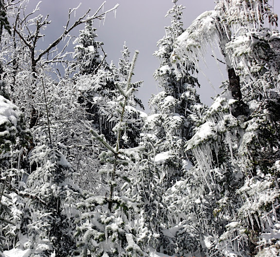
  • The snow was deep in spots, and progress often slowed to zero as we tried to gain purchase over deep traps. Twice we had to basically take a deep breath and just push on through. tMail, this was a LOT like we saw on Carrigain, except without the ice. The trees had dry snow on them that easily shook off, but no ice.
  • As we worked our way up, we soon noticed that as we zig-zagged it was taking less and less time to reach points where the ridge dropped steeply either north or south.
  • By 3500' or so we found that we could look left or right and see that the the ridge dropped steeply away.
  • A little above 4000' Bob noticed that if we looked straight ahead (and up) that we could see the ridge drop steeply to the right (south) with our right eyes and to the left (north) with our left eyes without shifting our glance.
  • Around 4300ft we hit a notch or saddle that dropped down at least 6' in elevation and was only about 50' long. On the other side it rose as steep as Lion's Head... almost intimidating.
  • Just before we got above treeline we had to skirt the left (north) edge of the ridge in Bob On The Edge
    order to avoid getting trapped in the trees. The pic at right is looking down on Bob's head. The snow in front of him is a drift that drops off at least 1000' into Lincoln's Throat. We were holding onto trees about 4ft from the edge. Click on it to zoom and take a good look. We were right on the edge.
  • Above treeline, the ridge was so narrow we had a few puckers. PM, the jumble of rocks you and I noticed on Tyler Day (which we thought we'd have to climb over rather than around) had to be climbed over, rather than around. 'Around' would've been foolhardy on the south side and stupidly dangerous on the north. Luckily the rocks we had to climb were not ice covered there or we wouldn't have made it. There was enough hard ice to make us careful, but in general we had pretty good traction.
The only other thing worth mentioning for the future is that two weeks ago I had to turn around due to being trapped in the trees. Then I stayed to climber's right. Today I kept moving left (north) and it turned out to be much more navigable. If you do the 'Bone, prejudice your route to the left.

From Bob: Certainly a nice day for a walk in the woods. Mutha Z you were a machine grinding up the bushwack. Not a route for a poor visability or really windy day, but a great route. I left big cheese-its every 18 steps, so we should be able to retrace our route. You could go down, but I prefer to have my face into hill and not see earth falling away everywhere I look.

3.28.2008

It's Decided: Sunday...

... is a hike up to, um, uh, ... okay, it hasn't all been decided, but we're getting there. tMail is running a 77-percentathon tomorrow and on Sunday we ... uh... do whatever we end up doing. We're getting about another four inches of snow in Danville and are expecting some bitter cold. Current forecasts (for Danville) are for 4°F Sunday morning. It's likely that things'll be a tad chilly, but calm and sunny on Sunday.

More information as the plans develop. Likeliest candidates: Edmands via The Castles and The Backbone.

[Update 3/29, 10am] The final decision: unless anyone who might be coming along has any last minute changes of attitude, the consensus is: Lincoln's Backbone. This will make the third weekend in a row I spend bushwacking, but I'm kind of into it. Conditions will be hard to anticipate. I'd guess there's at least 6" of new snow up high on the ridge, unless it's all blown off into the ravines. tMail and I saw combinations of strong crust and weak older snow on Carrigain that made the crampon/snowshoe decision a little tough but high up we were grateful for the snowshoes. The only gear I'm specifically not bringing is poles. They'll just tangle in the boughs, and if we make it out of treeline we'll want axes anyway. As far as poking into Tucks is concerned (from the USFS):

"As active loading continues through the day it's good to remember that a number of our avalanche paths have been running to their historic maximums. With this in mind I wouldn't get too close to the floors of either ravine even if you're just 'taking a look.'"
[Update 3/29, 5pm]
Meeting Time: Between 8 and 8:30, goal of starting around 8:30am.
Meeting Place: East side of 93 (Northbound) in the Lafayette Place parking area (south section of parking area).
Route: Falling Waters trail to bushwack turnoff (approx 1 hr up trail, head up left-hand ridge just before final brook crossing). Seek treeline and eventually Lincoln summit. Descend via Falling Waters or OBP depending on conditions, time and mood.

3.26.2008

Upcoming Adventure

MadDog is out for this weekend (3/29-3/30). Conditions are changing rapidly at higher elevations, although in general it's: blowing snow, frozen fog on a bomb-proof substrate of ice.

Below treeline it's firm/crusty snow and ever-softening snow in the warmer, sunnier places - and the next few days won't change that picture much. There's a possibility that between Saturday and Sunday there will be a transition to sunnier weather but that's still a long way away in forecast land.

I have a few thoughts on adventures, but some of them are big days out:

  • Edmands Col via the castles. We've done this before, but Edmands owes me and tMail. The MPM and I had a great time of it but it's got a certain draw and conditions are always changing.
  • Isolation. WTF? Ayup. It's not a bad idea. Glen Boulder with a finish down the Davis Path. Because of spotting cars it will be a later evening finale, but that could take place at the Red Fox restaurant in Jackson.
  • Lincoln's Backbone. tMail and I had our fill of bushwacking and daredevil adventure, but another week another adventure. Why not do the big manly struggle and try getting up out of treeline? Sure Carrigain made it seem like this could be nearly impossible, but in three hours I was able to get from my car to the 'I give up' point (2mb QT). Couldn't we go further with two or more people? And to be honest, it's not as hard a bushwack as we saw on Carrigain. I do have a few concerns about that ridge near the top, but we not even get that far.
  • Hillman's. Suicide mission? Avi danger? Sure, but that's today. We still have a few days to go and don't we want to check out the avi excitement in Tucks?
Think about it if you're available this weekend.

3.22.2008

Happy 42nd tMail!

tMail bagged Carrigain today. More details to follow, but I do have one comment. Winds on the Bad Boy slowly dropped from the 100's to around 80 today and are inching back up. We saw The Bushwack
huge winds - streaming snow - gusts ... in Crawford Notch. On the entire 8.5hr hike, the only winds we experienced were when we climbed the tower on Carrigain and they were probably maxing out at around 20mph in some of the bigger gusts.

We followed two guys who broke trail about 45min ahead of us. They lost the trail on the switchbacks (see red trail on pic at right). We bushwacked the green trail. That was the crazy part. (Click the map to zoom.)

Pics are posted: [tMail's Pics] [mutha's Pics]

From tMail:

"if you could make an analogy the Bushwhack was like this...if you are driving on a nice paved road with a set destination and then decided to drive 100 mph up a cliff through trees, stumps, deadwood, falling ice...it would go something like that..."

From Mutha:
"Initially, we were just climbing upwards on a steep, heavily wooded slope. We packed our poles to keep them from snagging on branches. A few traps gave us some challenges, but in general we were just fighting Start of Bushwack
gravity and branches (see pic at right). But the higher we got, the icier the boughs of the trees and the fewer the deciduous trees. Soon we were pushing/pulling through dense spruce/fir groves with interlocking boughs covered in ice up to four inches thick."

"Imagine a rack of clothes in a closet that is a hundred feet across, with poles places every 2 feet. Now add hundreds of racks above and behind - like a jungle gym, thick with clothes from all the bars. Then imagine that we have to climb through the clothes and work our way to the top rack, all the way in the back. Lastly, add to this picture that all the clothes are wet, covered in thick ice, are all fused together, and the poles have sharp sticks radiating from them ... and there's snow everywhere and you have a backpack on and snowshoes ... and scattered randomly throughout the poles and racks are special ones that can break unexpectedly when you are relying on them for support."
Also, in the course of doing some online research I found two great sites, linked on the right sidebar in the "Recreation Links" section: "White Mountain Lost Trails Project" and the UNH online historic USGS maps. These are two great resources.

What Fresh Hell Is This?!?

The forecast is nothing but ice, snow and wind for the next two days. The MWO is forecasting record-high winds (in the last year or so). There will be so much snow moving around today, tonight and into tomorrow that a Saturday trek is hard to decide. tMail and I have exchanged a few emails about it, and the possibilities include (but not limited to):

  • Carrigain (on tMail's 48 list)
  • The Bonds (although the key bridge into the Pemi is out - also on his 48 list)
  • Lincoln's Backbone (again, but hopefully above treeline this time)
  • Something where we can check out the avi runouts on Washington
  • ...
I've got to bolt my snowshoes back together.
[Update 3/20 4:30pm] I'm testing the idea of using 'Sticky Posts' with this article. The idea is that I'm post-dating it for Saturday so it stays at the top of the page and any new posts show up underneath it until Sunday.

[Update 3/21 8:30pm] Nice. "15 min" peak speeds at the MWO have hit 140mph. Luckily winds are supposed to calm down into the 90's by noon and even lower by tomorrow night. Eeeegads! tMail and I decided on Carrigain via Signal Ridge. Take a deep breath... okay, step, hold tree... step... hold tree... step...step, stepstepstep ahhhhhhhhhhhhh......!.

[Update 3/22 5:30am]
"As a result of a blocking pattern, stalling and intensifying a center of low pressure in the Canadian Maritimes, winds peaked at 149 mph yesterday, with an average of 104.5 mph for the day. [...] The air aloft will be pretty dry, but the strong winds will be more than sufficient to lift the lingering low level moisture up and over the summits, providing fog for much of today and tonight. Winds have dampened to below 100 mph, but they will still be above hurricane force for much of the forecast period. Blowing and drifting snow and freezing fog will continue to contribute to severely limited visibility above tree line, with white out conditions prevailing at times."

3.18.2008

Snowshoe Drama and Resolution

I talked to Tubbs today about my popped rivet, and got some bad news, some good news and some heh, heh, heh.

The Bad News: Turnaround is now about 3weeks for repairs so I'll probably wait until after the season ends in a month before sending them out.

The Good News: Tubbs doesn't care if I bolt the thing together with some screws and washers as long as they can repair the original busted rivet (i.e., as long as I don't drill a larger hole at that spot). I just have to drop the shoes off at any dealer, no receipt needed (lifetime warranty). Tubbs Mountaineering Shoe


The Heh Heh Heh: At was browsing their site and have fallen for their new Mountaineering model. Improvements include: quick-release cinch straps w/ some kind of fucked up tension control thing. I've used it on their Sojourn shoes (the new ones I won in the Mad River Uphill race) and find them convenient, comfortable and quick to manage. The plastic strap bindings I have on my older (now busted) shoes are kind of sucky, Heel Crampon
even though they are pretty aggressive.

But here are the two best things: First, Tubbs finally added heel-lifters like on the MSRs. Secondly, the aggressive stainless steel full crampon is similar to my current pair although they've improved it with a crazy curved talon like a circular saw blade on the heel crampon. This thing looks like it could chew through alpine ice. This is my next christmas present, no doubt about it.

3.16.2008

Lincoln's Left Arm

I gave it my best shot today. I bushwacked up the ridge toward the Lincoln summit via the route that Tyler had outlined - more or less. I hiked up Falling Waters to the spot where it crosses the brook for the last time at the 860m contour (before it bangs right and slabs up along the old road bed). I headed straight up the hill  Bushwack Route
where I had test-climbed on Tyler day, and then up to the ridge and worked my way up pretty far. I got to the 1200m contour (about 3940ft) where I had to turn back. This is almost the elevation of the Greenleaf Hut (about 200ft below it) but on this ridge it was still about 600-700ft below treeline. I turned back at noon. I had decided earlier that because I was solo I wanted to make treeline by noon or turn back.

The best footwear for today's conditions would've been snowshoes - but when I started out I hadn't even made it to the trailhead and I felt a *SNAP* from my Tubbs and noticed that I had just popped a crucial rivet. Luckily I had my crampons in the car and went back for those. The steep part of the ascent was crampon-city, but once up on the ridge snowshoes would've been a great help. I was postholing between knee and bellybutton deep. Several times I dropped in so far that after a few minutes struggle to get out I looked in the hole and couldn't really make out the bottom. I was on snow at least 6ft deep.

The hike starts out looking exactly like you'd expect from the woods around Falling Waters: deep forest of spruce, red pine, birch, maple, etc. But then it starts to close in. Much of the time delay was due to having to push through extremely dense growth. This is NOT a good hike if you have even a little claustrophobia. Many times I had to get down on my chest in the snow in order to find a route while crawling through the branches. On the way back down, following my footprints, I frequently couldn't see them through the spruce branches.

Most of the experience involved getting whipped in the face, postholing, breaking branches, struggling and climbing.... and being wet. I anticipated having to change frequently, and with temps in the high 20's or more, snow, sleet and light drizzle to start, I was soaked. I went through four pairs of gloves, three hats, and my Precip was soaked!

At around 11:30 I had reached the part of the ridge where it is Looking Down On The OBP
noticeably narrow - obviously dropping off left and right within 100ft of where I was and narrowing rapidly as I ascended. This narrowing also reduced the number of route options. Weirdly, the ridge is heavily forested. I know there is exposure up high, but it seems like tree line is a lot higher than on Lafayette. I took some brief footage (Click Here to view) that I made at about noon when I thought I'd have to turn back. But after eating a sandwich and having some water I took a deep breath and actually belly-crawled through that spot and kept going for another 10 minutes or so - eventually reaching a point where the trees were just absolutely impenetrable and the snow menacingly deep. (The video makes it look like it's relatively open, but it's an illusion. The spot in the video has to be *crawled* through.) I really did try to continue on but I gave up while flailing about up to my nipples in snow in the high tangled boughs of a deep fence of spruce. Where I turned around you could only see about two feet ahead.

At around 3,700ft I used my axe to hack a pattern of nicks into a dead tree trunk (at about head height). Next summer I'm going to find that tree and see just where the hell those marks are. They better be 20 feet up.

That said, it was a little over three hours from car to turn-around point, and 1:45 back down - basically a 5 hour jaunt. It was just as well I turned back then. Temperatures were started to drop and the wind was picking up. Pics are posted on Picasa.

It's really an interesting place though - I'm going back one day.

3.10.2008

Hard Crust

Today's lunchtime outing features a 90 minute trek across nearly bomb-proof crust. It didn't have a hardened ice surface, it was nice and cruncy like running on granola bars. We even did some relatively steep down- and up-hill and the grip factor was pretty high. Danville is just covered in the stuff. Spanky on 4ft of Snow


There's a slight complication with streams running a little high from the intense rains we had, but the hard freezes have cemented the snowpack and the water will have to find new/temporary routes.

In some of the most sheltered spots it's still possible to drop two or three feet in soft pockets, but those are pretty rare. Any well worn trails (falling waters, for example) are probably crampon-only, but off trail is going to be good for barebooting. The posthole problem is pretty severe and I think something like the Lincoln Ridge would be good in snowshoes in the trees, and then crampons above treeline.

I'm ripe for an outing.

3.09.2008

Bail Out!

The storms that came through yesterday and last night left the power out all over the north-east and into Ohio and Indiana.  Click To Zoom
We had torrential rain, high winds, icing, minor flooding and super-saturated snow. The temperature is plummeting and the winds are still high and I just couldn't bring myself to head into the hills. It looks like the sun will come out as the bitter cold sets in so I'll probably do a crust-run w/ the pooch - but with completely unknown snowpack conditions I don't want to be slogging around in freezing unstable slush.

I imagine that many areas are undermined by water sifting down and hitting impermeable layers (either crust or ground) and flowing horizontally. I'm eager for news from Tucks to see what the coming three days of bitter cold sets up. I'm hoping it becomes bullet-proof armor.

3.05.2008

Mess o' Winter Storms

With all the warm precip in the last day and another storm coming up for Fri/Sat it's not clear what the outlook for adventure will be until later this week. I'm sure by Thursday evening we'll have a clearer picture. Any ideas are welcome (except Lincoln's Throat or adjoining ridge, which will have to wait for the snowpack to consolidate a bit).

[Update 3/6, 9pm] The forecast for the next few days includes another winter storm watch, ending Sunday morning. This includes rain, sleet, freezing rain & snow, followed by sub-zero temperatures Sunday night. It seems likely that I won't want to drive in this on Sunday morning, but the next week looks like great weather to get the sap flowing (warm days, freezing nights) - which means setting up the snowpack for early spring adventure - and lots of it.

3.03.2008

MWRR: Waiting For The Lottery


It's official. The Lottery is open from now until March 15th. Waiting... always waiting ...

3.02.2008

Avi Craziness

This weekend's "Weekend Update" and Saturday's avi bulletin posted by the Mt. Washington Avi Center read like great fiction. Conditions are out of control and getting more active every day and the tension is building. I have two links here to copies of these documents that I preserved for fun [Link to Weekend Update for 2/29/08] and [Link to Avi Bulletin posted on 3/1/08] but you can always get the most current information [Here] and [Here] respectively. The pic at right is from TuckermanRavine.org and shows a fracture line below Lion's Head on 2/29/08. Click on it to zoom or go to the original site [Link] to see more photos.

Here are three great highlights:

"Over the past 3 days we have seen avalanches in the Escape Hatch, South gully, Yale, Damnation, North, Gully #1 near Hillmans, Gully #2 near Hillmans, Dodges Drop, Hillmans, un-named line on the Duchess Buttress, Near Left Gully, The Headwall-Lip, Sluice, Right Gully, Lobster Claw, and the Large Lion Head Snow field that ran down towards the summer Lion Head trail near treeline."

"Then on Sunday winds will rage and push into the 85-95+ mph range from 9am to 6pm which will continue loading and another round of avalanche activity. "

"The Lion Head Winter Route is not one of our forecast areas but does have potential to produce avalanches as anchors become covered and the snowfields increase in size."


3.01.2008

The New Obsession

I can't stop thinking about Lincoln's Throat. These guys were up there a few years back. So were these guys (and they've got a map). There are three hikes I want to do:

  • The Ridge (Ty/MPM's original plan)
  • The Throat
  • A Hybrid (not sure what this means)
I may wait for some good March freeze/thaws before trying the throat, but the ridge can be done soon. I know it wasn't the right time on Tyler Day, but the truth was I was standing on the crust when I scooted up into the trees. That was the place to do it - right before the last brook crossing where Falling Waters bangs south along the old logging road onto Haystack's main ridge.

In fact, I came down a great spot to ascend off the trail.

I'm heading back up there. I think I'll do the ridge first and scout out the throat. It doesn't look as steep as Dodge's except at the Ice Fall, which is why I listed a "hybrid" hike. I think with the well-developed ice fall we'd have to exit the gully early and find an alternate route to the summit... or, as Tyler put it, just head back down.