12.29.2008

Thursday's Great Adventure

tMail and I have started the warmup to Spungie Day (Jan 3/4). We're heading out on Thursday, January 1st and are contemplating some routes. The primary candidate is to revisit that hell they tMail In The Mist
call Edmands Col. The route is probably up over the Castles, hit Jefferson, navigate the Col, tag Adams (or not) and descend via The Gray Knob.

For historical reference, this was the ill-fated trek where tMail and I turned around just north of the Col and headed back down the Castles while the PM and g-$$$ did the same thing from the Madison side of the range.

Picture Gallery from that trek is here.

12.26.2008

Hell Brook: It Never Fails To Deliver

Mad Dog and I braved Hell Brook today. As the title of this post states unequivocally, Hell Brook never fails to deliver. We started out at 9am, and 1.5 miles and over 5 hours later topped out on the ridge. We hammered another 1/2hr or more and turned back not 100 yards from "The Adams Apple" of Mt. Mansfield. I'll attempt to describe just how gnarly this trek was, but the bottom line was we wished you guys were here. This hike so kicked ass in so many ways it was just plain fun fun fun fun. For the PM, who's been up there in the shizzle, this was no better or worse ... just different for reasons I'll get into in a sec. While I'm typing this my pics and videos are uploading from my camera. I'll get to those later and post to picasa or youtube. In the meantime...

Mutha's Trip Report: At the cars, we seriously considered taking our snowshoes (which we both brought). Just like the last time w/ the PM, maddog and I decided NOT to bring them - but I promised that this time, due to my bronchitis I was not going to run back to the car to fetch them. No snowshoes. Great idea.
  1. We didn't need snowshoes, praise Allah... for the first 1000 vertical feet. Then we needed snowshoes. The snow varied between 1 and 8ft deep in long drifts that filled in the ravines in unpredictable ways. We broke trail the whole way up, moving so slowly that at times it seemed like we were never going to make forward progress again. Hours passed, while the conversation kept going, and going, and going. The pace slowed to a nearly glacial rate. We had crampons on, but each step could result in a plunge to crotch depth. Each pole plant could result in the pole dropping down, plunging an arm to elbow depth. It was agonizingly slow.
  2. We developed a technique we call "The Hell Brook Crawl" or "The Hell Brook Swim". It's a method to get up steep snowfields that aren't strong enough to support your weight. The technique is like crawling on all fours, using your knee-to-foot surface (shin) for flotation and plunging your fingers/fists into the crusty snow. In really weak snow you can belly crawl, but UP a VERY steep incline. I can't estimate the slope, but it's pretty damned steep. All told there was more than an hour of this crawling, so my shoulders are shot.
  3. As MadDog phrased it, thankfully we have crotches. In many cases this was the only thing keeping us from dropping deeper. We had many instances of standing delicately, bellybutton deep, and suddenly one foot starts to drop. We freeze, holding balance, drop again... then again...start swimming.... minutes pass and no progress has been made but we didn't smother.
  4. After topping out on the ridge, we made an attempt at "The Adams Apple". This final ascent was through krumholz filled with drifts. The decision to turn around came at this point: I was leading, breaking trail. MadDog followed, also breaking trail because things were so unstable that my progress barely helped. The grade was very steeply pitched and I was using the little tree-tops for support when the snowpack began to collapse under me. I ended up on my back (it's hard to explain why) with both cramponed feet jammed into treetrunks, my pack resting on the remaining snow, my hands holding little tree tops. I was on my back, spread-eagle over a collapsing crater. The cavity under me wasn't any more than 5ft deep, but to drop into it meant only being able to continue back downhill. I made the decision to turn back - it was already about 3pm (6 hours into the trek, a little over 1.5 miles from the trail head.).
  5. The trek down was a different world from our trek up. There was another couple on the trail (more on that later, or from MadDog) so the trail was well packed in and could almost be walked casually. I don't recall the time, but I don't think it took more than an hour to get down - and that was walking, not glissading!
  6. Great conversation and great companionship. It was adventure of the highest quality.
MadDog's Trip Report: Once again we were beaten up (badly) by that trail they call Hell Brook. How bad you ask? Well, it was post holing for just about the whole day, and so deep that I relied on an improvised crotch-stop technique most of the time to prevent me from going completely under the spine of the Greens. It was just another absurdly hard HB hike. Like the last we (PM, MZ) bushwhacked it, but different. today it took us about 5+ hrs to travel something like ~1.5 miles. We were just shy of crossing over to the LT before calling it quits. The decision came when Mutha was suspended above the snake pits, spread eagled, with nowhere else to go. Another way to envision the day is - if you can imagine this, it was like being armed with spears, then getting locked in a UFC cage and being pitted against 5 fast moving midgets, in a fight to the death, all the while, the fight producer is pulling levers on secret trap doors causing you to fall and thrash. I'm not much of a fighter, but we managed to pull on trees, stomp holes, swim, and crawl our way up that thing today. Kudos to Mutha for being the lead plow. We also met up with a nice couple (Bob, Jess and Ramble) at the tail end near the turn for the LT and then later on the return...we have some beer drinking rain checks to cash in at some point. And finally, on the return back to the bungalow, I met up with the Morton's Fisherman and returned his suit. I told him I wouldn't need it any longer. He asked, why? I said four Xmas great and generous Xmas elves had upgraded me. THANK YOU, Xmas elves!!!!!
Pics Posted Here.

12.22.2008

Vermont Weekend 12/27

The PM is doing it. mutha's doing it. tMail's doing it. g-$$$? maddog? And just MadDog on HellBrook
what is that we're doing? on Saturday, 12/27, we're doing the Bamforth Ridge trail to Camel's Hump... or the Hell Brook trail up Mt. Mansfield.

Be there or be square.

The PM will be in Vermont from 12/24 onward, so we have a week's worth of festivities (on and off).

[Update Christmas Day, 2008] Okay, it looks like a weekend of rain. I'm guessing this whole idea is shot to hell. To salvage what's left, there's always tomorrow (Friday). It ought to be a nice day: a night of wind and rain and warm temperatures on top of several feet of soft, cold snow. What the heck is this all about?

[Update Christmas Day, 2008: Snowpack Analysis - Danville, Vermont]

Conditions prior to rain:
exceptionally dry, low density snow - roughly two feet of it - maybe three in filled-in hollows. it was pretty fresh and what little water vapor was available in the ground was locked down by a layer of ice from before the snow and the cold temps prevented much more from filtering up. There was some blowing around, but not enough to make a significant wind crust.

Then came the rain:
Steady and copious quantities of rain and warm weather yesterday, along with high winds. The winds didn't pick up until after the rain had thoroughly saturated the snow so nothing really moved around at all. Temperatures will be plummeting tonight but as of 3pm the snow hadn't firmed up at all even with air temperatures below freezing (and ground/snow temperatures colder still). While the snow seems to have consolidated a bit, it doesn't look like it'll freeze up hard enough to come a supporting crust although we won't know until morning. I tried walking in the snow with no snowshoes and sank right to the bottom. Even the dog avoided going off trail because it hadn't lost that much depth.

Tomorrow in the Greens:
Not sure what the ramifications are, but I expect to see deep snow that probably requires snowshoes to stay afloat. Crampons may be necessary ice falls, but except for a few ice walls it's probably all covered in snow. I can't wait to see.

Spungie Day II (2nd Annual)

Spungie Day I
Prepare ye the way of the Spunge. There'll be hell to pay for what were going to do. It'll involve snow, wind... Spungie. Who knows, there might even be ice.

Prepare ye.

12.21.2008

Winter Weather

Maddog, this is for you and me (from the National Weather Service):

"... STORM TOTAL SNOWFALL OF 10 TO 15 INCHES IS
EXPECTED ACROSS MUCH OF CENTRAL AND NORTHERN VERMONT FROM THE WEST
SLOPES OF THE GREEN MOUNTAINS EASTWARD."

and then there's:
"655 AM EST SUN DEC 21 2008

...RAPIDLY DETERIORATING TRAVEL CONDITIONS EXPECTED MID TO LATE THIS
MORNING ACROSS THE NORTH COUNTRY...

MODERATE SNOW WILL RAPIDLY OVERSPREAD THE NORTH COUNTRY FROM
SOUTHWEST TO NORTHEAST THIS MORNING. SNOW WILL BEGIN BY 8 AM ACROSS
MOST OF NORTHERN NEW YORK...AROUND 9 AM IN THE CHAMPLAIN
VALLEY...AND BY 10 AM ACROSS CENTRAL AND EASTERN VERMONT. ALMOST
IMMEDIATELY AFTER BEGINNING...THE SNOW WILL QUICKLY INCREASE IN
INTENSITY...RESULTING IN LOW VISIBILITY OF A QUARTER TO HALF MILE
AND SNOW COVERED ROADWAYS. SNOW MAY BE HEAVY AT TIMES...WITH
SNOWFALL RATES OF 1 INCH PER HOUR LIKELY LATE THIS MORNING INTO
THE AFTERNOON HOURS."

12.16.2008

Fri/Sat/Sun (12/19, 12/20, 12/21)

The PM and tMail are planning a big shindig for Friday. My last day of classes is Friday so it'll be either Sat or Sun for MD and me. g-$$$ might be able to make any of the three, so we'll leave this post out here for ideas/plans/etc. and see how things evolve over the next day or two.

We've got a winter weather advisory posted for tomorrow. It's only 3-5 inches in Danville, but apparently it'll all come down between 10:00am and 10:15am.

[Update 12/20, 1pm] Well, it was just too much to get out this morning. tMail would've crawled to NH if he had to. MD and mutha were just too beat to manage it. We have a day of rest and shoveling the white powerdy yum-yum and now tMail is starting the drumbeat for going hiking tomorrow in the middle of a winter storm. Hmmm, sounds somehow appealing....

Stay tuned.

[Update 12/20, 5pm] It's just not gonna happen. We've got so much snow in the forecast for Sunday that tMail and I called it off until next weekend. We're available Fri/Sat/Sun and hope to take advantage of these enormously snowy conditions on one of those days. This should be great fun.

12.14.2008

The Winds of Thor

Mt. Washington. That is such a bad-ass mountain. tMail and I took the Lion's Head (Summer) route up and down - 6 hours on the dot. The weather was terrific. The MWO reported winds between 60 and 70mph, but the summit was nowhere near as impressive as the trek from the Lion's Head outcrop to the Alpine Garden trailhead. Last winter's BadBoy was probably worse, but only because it was a steady freight train wind. tMail and I got HAMMERED. We had time to play around in it and both had the experience of leaning forward and having our full weight held. After leaping around and nearly getting thrown off the mountain I had the unfortunate experience of getting shoved by a strong gust and held in place standing for about 5 seconds. What the hell!

Mutha's Trip Report (pics): We had a few bad omens on the way up:
1 - The winds were howling in the woods
2 - The first guy down was an ice climber who had played in Huntington Ravine and commented that he had a horrific time on Lion's head in the wind.
3 - Next, a solo hiker on the way down claimed he didn't dare summit because of the blowing snow and horrific winds.
4 - Then, in the shelter of the Lion's Head boulders (the lower ones) a group of four french Canadians were clearly spent, and the woman near mental and physical exhaustion, claiming the winds were 'terrible' and that with the coming storm, it was foolish to continue on.

Bunch of amateurs. tMail and I had the greatest hike. It was warm (hovering around 15-20°F), really windy, but extraordinarily beautiful. Pics will be posted later tonight or tomorrow, along w/ some video. Taking picks while being knocked around by wind isn't easy, but we had to bring back evidence.

Transcript of brief conversation on bridge, on way down, while staring at Cutler River:
tMail: Let's check the itinerary and see if we did everything.
Mutha: Go for it.
tMail: The Winds of Thor were blowing cold.
Mutha: Check.
tMail: The Dogs of Doom were howling.
Mutha: Check.

For some great fun, click on the lovely, serene photo at the right and enjoy the beauty and tranquility of the White Mountains. Really stare hard at it and enjoy the serenity. I mean REALLY enjoy the serenity.

Then check out this 11sec YouTube video of the same scene, taken a moment later.

[Update 9pm] Mutha's Pics are posted. tMail's Pics are posted.

tMail's Trip Report: First off Bad Boy and I have a very special relationship one that sides on the side of caution. I was telling MZ like no other mountain I am more reserved on Bad Boy. I don't know what it is about the mountain but MZ and I did numerous check on time, weather, ability to spot the trail behind us. We made summit and returned. I think all of us know each other well and no limits and trust others making judgement calls and knowing that the decisions at any time can be reversed.

  1. Arc Teryx Shell unbelievable all I had on going up Bad Boy was a base layer smart wool
  2. Patagona Backcountry Guide Pants unbelievable the vents work awesome, suspenders awesome great great pants.
  3. Tec Wick long underwear EMS awesome did not have any issues with legs getting overheated i regulated temperature well.
  4. Goggles no issue what so ever...key is keeping face moisture down and good ventilation.
  5. EMS windstopper shirt awesome the wind was howling below treeline this shirt did the trick.
  6. New EMS mittens that are not bulky filled with primaloft awesome work them the entire day vented well and stayed dry inside.
  7. Helly Hansen hat wore it from start to finish.
  8. We moved at a good pace but I seemed to do the moisture management well if i got hot opened vents, took a layer off etc etc...
  9. I told MZ the winds didn't really surprise me or us...talking to other people they were taken off guard and some looked like they were abducted by aliens. I think our past experiences paid dividends.
  10. Once I was able to lean fully forward and be held up my the Winds of Thor.
  11. This was probably one of the best hikes I have been on it had adventure, it was peaceful, spiritual coming down Bad Boy was awesome nobody around us the sun came out and the snow, ice and cairns you see for miles. I told MZ I always wanted to be on Bad Boy in the picturesque setting and finally made it...

12.12.2008

Sunday, 12/14

This is just a placeholder post while tMail and I figure out what the plan is. Anyone thinking of heading to NH on Sunday, post hike ideas in the comments section and I'll throw them out on this main page. Sunday ... hmmm... what do we know: fresh snow, ice, crust... sounds like great cramponing. Better check the MWO report on Saturday morning.

[Update 12/13] Word on the street has it that the Bad Boy is the likely destination in order to "look hell in the eye" or something like that. Conditions should be cold and windy. Avi conditions are stabilizing with rain saturated snowpack locking tight like concrete.

12.11.2008

The Winter Storm

The heavy rain you kids in Beantown are seeing is moving north as all snow. in between, in g-$$$-ville, it's looking like freezing rain and snow and other stuff.

It looks kind of mixed on the bad boy.

The bottom line: it looks like this is the first of many storms to lay down a beautiful, chewy base (I know the stuff on Jackson was terrific). While i get my hopes up every year, last year we got hammered with so much rain that the bottom base was hard, nearly unscratchable ice. Maybe this year it'll be a snow layer bonded to the rocks that becomes the gift that keeps on giving. Of course by spring it could be the weak layer for many terrific avis, but until then I've got hopes for a great season.

12.09.2008

The Next Big Adventure

This week is shaping up to be quite the week for laying down some nice base layers of snow/ice. I went x-c skiing for the first time - had to use a headlamp - but conditions are pretty nice down in Danville. I imagine that there's a nice base being laid down in the mountains.

You may have heard that the MWO satellite antenna had its protective cover ripped off by 120mph winds last weekend. It was -20° (-80° wind chill).

Like MadDog, I have to be at a social function at around 5 or 6pm Saturday night (the same one, in fact). This means something light-weight for saturday for me. There's always Sunday - nothing like a big hike with a hangover. Any ideas?

12.02.2008

Slow descent to 12/6: Holiday Ennui

It's time to start the chatter about 12/6 (Saturday). Maddog is out (I'm pretty sure) and I have to be back early. It's a 'tween holiday weekend which makes it a bit suspect for getting a large group together, so I've already got a backup plan if nobody else will be around: Jackson, for my third and final finish of my 96. Great Caesar's Ghost!

[Update 12/6 6:30am] Spanky and I are packing for Jackson. With a 10°F trailhead temp we'll be as cold as we've been all fall. I'll bring her coat for emergencies. We're just going up the Webster/Jackson trail from the AMC lodge over by Saco Pond so this won't be a huge event, but the cold will be a good reminder of what winter is. We're not planning on hitting the trailhead until 9am to let the sun come up and warm things for a few hour so this will be quite the leisurely jaunt.

[Update 12/7] Didn't get around to uploading pics until this morning due to rockin' party at mr. & mrs. maddog's last night! woo hoo! done w/ 96 (for real).

11.28.2008

Chocorua

None of the above (or below). tMail and I are hitting Chocorua from the Piper Trail, hoping to loop over the summit and the Three Sisters, going up the Hammond Trail (from Piper) and down the Carter Ledge trail.

[Update] We'll probably be doing it in the reverse.

Mutha's Trip Report (Pics Here, Video Here):
  • tMail banged the untrodden trail the entire way. Once we left Piper, we were able to follow the actual trail for the most part, with some minor bushwacks. The last bushwack off the Left Sister was kind of harrowing Elev Vs. Time Plot
    because the view from up there was DOWN into a nearly vertical notch over 150' below. It dawned on us that we might not make it back by dark, however the plunge into the thick of it turned out to be only about 15 minutes until we found the trail again.
  • In the Book, the ascent of the Three Sisters carries the warning that in wet or slippery conditions this route is to be avoided. No kidding. We were both missing a few key pieces of gear: gaiters, crampons, axes, helicopter, ladder, flamethrower and pack-mule. On the other hand, the bareboot thing was hysterically fun and sketchy enough to suggest danger.
  • g-$ claimed that his two first attempts to summit this sucka were foiled by conditions. No crap. This mountain in completely unassailable except in Photo Credit: tMail
    exceptional conditions.
  • It took us 3:45 to ascend to summit, and 1:15 to descend to car. On the way down we surprised two snowshoers. We figured they'd hear us (mutha: "we sounded like a herd of elephants", tmail: "we sounded like a herd of angry rhinos"). They didn't. One lady almost fell over from shock. I felt pretty bad because of the horrified look on her face, but we were gone by the time I stopped laughing.
  • All the summits over 4k were totally socked in. We had bluebird skies the whole day.

tMail's Trip Report (Pics Here):

The Gear I had:

1. 3 Hats
2. 1 Pair Heavy Gloves, Liner Gloves, Shell Mittens, OR Mittens
3. Smart Wool
4. Dufold Mid Weight baselayer
5. North Face Cipher
6. Mountain Hardwear Windstopper Vest Photo Credit: Mutha

7. 2 Headlamps
8. Med Kit
9. Bivy Sac
10. Food and 2 Liters
11. A random pair of Injinji socks that must have been stuck to my smartwool
12. My wallet so I could pay for my mountain rescue.

Gear I should have had:

1. Ice Ax 2 of them
2. Crampons
3. Gaiters
4. Plastic Boots
5. Soft Shell Pants

Chocorua is a cool mountain it was pretty gnarly going up via the Sisters there was one time MZ went left I went right and was on snow covered rock slab...MZ said Tmail, "If you fall just yell something" I called his name to test if he would hear me no shot I would have slide to 302.

Off Middle Sister no clue everything seemed like a drop off up there. Once on the ridge to summit either side is a straight drop off to the death.

And file this under technique 137 going up ice next to tree shrubs...get on all fours and get as close to the tree as possible head ram the lowest branch until it breaks off slide on stomach until you can use the tree to push off with your feet.

It was nice to blast down the Piper Trail.

Saturday, 11/29

IT STARTS: tMail started the chatter. it's already Friday and while we've tossed around the idea of going on a hike tomorrow we have yet to enumerate any options. g-$$$ suggested Sunday might be better for him, I think MadDog said he can't do either day, the PM had mentioned a bum knee, and now that I finished my 96 I'm pretty much up for absolutely anything, either day with no obvious preferences. So right now things are kind of floating in the air.

WEATHER: Here's what I know weatherwise: Today in the north-country we're getting a weird little instability that should dump a few inches everywhere. My neighbor's been grooming the x-c trails around here to lay down a firm base (which firmed up nicely with the recent rain and warm weather - promises to be a great xc season) so the added snow means i'm getting out on my skis next week. But that should be done by morning, leaving Saturday with remnants like light blowing snow and clouded summits. Sunday is likely to be the sunnier day if you're looking for a tan, but we have a serious weather system coming in on Sunday night:

A SIGNIFICANT STORM SYSTEM EXPECTED TO DEVELOP ON SUNDAY ACROSS
THE SOUTHEASTERN UNITED STATES WILL TRACK NORTHWARD BRINGING A
WINTRY MIX TO THE NORTH COUNTRY SUNDAY NIGHT AND MONDAY. MIXED
PRECIPITATION MAY BE HEAVY AT TIMES. HAZARDOUS TRAVEL CONDITIONS
ARE POSSIBLE DURING THE PERIOD.
It seems unlikely that this would make the drive home from a Sunday adventure hazardous since the expected start time is closer to midnight than noon.

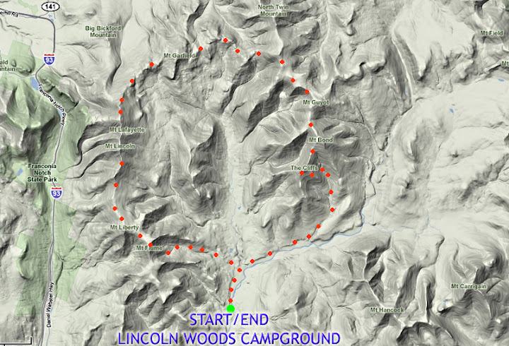
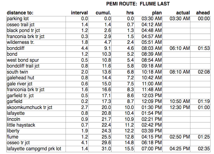
CONDITIONS: So what can we do? Franconia Ridge? F**k that. tMail and the PM were just out on Franconia Ridge last week and as unbelievably cool as it always is I kind of think of that as the hike of last resort. Adams? No way man. I'll do Owl's Head before that slag-heap. So what can we dream up? Well, let's consider the conditions:
  • light snow cover at lower elevations that's gone through some rain/freeze/thaw cycles - not enough to cover the rocks.
  • similar at high elevations, but more snow - although not quite snowshoe worthy and probably not crampon-ready above treeline.
  • temps seems likely to be in the teens with lusty air-blowage above 5,000ft but just lightly breezy below that.
  • with no liquid precip in the forecast, we will be limited to personal moisture control, but with 10lbs of thanksgiving in our bellies, do we really want to race over hill and dale?
ROUTE IDEAS: I'm open to suggestions - certainly anthing that offers a unique perspective on life and the outdoors. Throw out ideas in the comments and I'll post them here. Whatever we don't do we'll keep on file for later - although once MadDog is back on the trail we may end up focussing on the last of his 48.
  • Huntington Ravine (bring crampons and ice axe)
  • Something in the Carters? Well, tMail & the PM are planning something in two weeks.
  • Up Ridge of the Caps, over Jefferson, down 6 husbands, turn around in the Great Gulf and climb up the Sphinx Trail and back to the cars.... or is that what you guys did last summer?
  • Sandwich Dome?
  • xc ski lesson for tMail in Jackson w/ dinner at the fox?

11.26.2008

Thanksgiving

Each day I wake up and perform a little ritual in my mind. Tonight, in anticipation of a great day tomorrow, I want to put some of it in writing and add to it an annual ritual. It's a little list of things for which I'm thankful:

  • I thank the sun in the east for rising to find that once again, by some miracle, I am not dead.
  • I thank my house for shelter.
  • I thank my dogs, cats, chickens, horses and chuck the rabbit for filling my life with the peculiar camaraderie that pets bestow, and the worms for shredding my compost, and the spiders for keeping my world so clean and the birds and bugs and frogs and bees for being such good stewards of the land.
  • I thank the spirits of the earth for giving us the mountains and the water, and the spirits of the air for the wind and weather.
  • I thank my mother and my father for not selling me into slavery or cutting my throat or selling me for cash or whatever they could have done rather than raise me.
  • I thank Garvin, Steve, Tim and Nate, whose stalwart friendship, character, vigor, and love of life and adventure, and in whom I'd trust my life, inspires and amazes me every day.
  • I thank my wife Susan for sharing these things with me and giving me her constant companionship and the gifts of love.

11.25.2008

Upcoming Events

tMail and the PM had a spectacular-looking day on Monday. I was a little jealous. But the current forecast for 2000ft and above is for wet snow and high winds for the next several days. This could lay down a significant base for future snow and provide an excellent base for crampons. Whatever goes down over the remainder of Thanksgiving week will be a little snowy. For the last week in November and then for December we're looking at some excellent conditions.

11.23.2008

Osceolas & Tecumseh: Plan E

96. Done. Starting on 144.

I got a late start (8:30am) so decided on the following strategy: If I could tag the Osceolas from the Greely Ponds side from the Kanc and get back to the car by 1pm I'd drive down to Waterville Valley and hit Tecumseh. I got back to the car around 1:30 and guessed I could still make twilight. I didn't know how long it would take to get to Tecumseh, but spread all my clothes out in the car and blasted the heat to have dry tops and shell. That worked well.

I hit Tecumseh around 2:15 and was back at the car around 4:30, just at the end of twilight.

Notes:

  • I didn't bring traction or gaiters. Good choice, although the going was a little slow at times due to all the cascades on the Osceola Trail being frozen solid.
  • A long day out at about 0-5° takes its toll. The rapid transitions from hot/sweaty to cold/chilly are tiring.
  • Gear Note: need to find alternative to Precip shell... something that breathes.
  • Lost a pair of mitten shells w/ liners somewhere... not sure... think at Greely Ponds trailhead during change of gear before heading to Tecumseh.
  • Winds weren't bad - but things were howling in the woods. I've never had such high winds so far below treeline (at least 1,000ft). I think it's the geography of the area. It was pretty intimidating to think that it was only going to escalate at the summit. As it turned out, I never put on goggles and only had to wear my facemask on the East summit to avoid frostbite on my north-facing cheek.
  • Food Note: Osceolas: 1/2L of water, 1 sardine sandwich, 1 bottle boost. In car to Waterville Valley: 1/2L of water, 1 peanut butter sandwich, 1 handful of trail mix. On Tecumseh: 1L of water. On ride home: 3L of liquid, including 1L of chocolate milk, 1 Large coffee w/ milk, 24oz of Sobe peach mango something. Close to 3000 calories of stuff I don't even want to talk about. Basically, high fat, high salt, high carb, high protein, etc. At home: bowl of miso soup w/ noodles (thanks Sue), 1/2 salmon steak w/ capers and lemon, 5 chocolate chip pecan cookies, large piece of candied ginger.
  • Almost nobody was out. Saw nobody on Osceolas, one couple on Tecumseh.
Pics are posted [Here].

11.18.2008

Osceolas & Tecumseh w/out Spotting A Car

It's not that hard and it's barely 13 miles. It requires travel by car about 3 miles between hikes on the Tripoli Rd (closed in winter) but basically:

Route Plan: Drive to Waterville Valley and park at the Mt. Osceola Trail Trailhead in Thornton Gap on the Tripoli Road. Hit Osceola and East Osceola from the southeeast and return to car (8.4mi total). Drive back down to Waterville Valley and hit Tecumseh (4.4 mi total). Total miles = 12.8

Alternate Plan w/out driving - adds 2 miles of road walking, eliminates driving: Park at the Mount Tecumseh Trailhead on Tripoli Rd. in Thornton Gap, about 1mi west of the Mt. Osceola Trailhead. Hit the Osceolas, return via foot, walk by car and hit Tecumseh. Return to car. Total miles = 16.6. (Note that parking at the Tecumseh trailhead makes sense because its downhill from the Osceola trail to Tecumseh trail.
If you're wondering why in the second scenario you don't just drive between the trailheads, I don't know ... it just seemed like we should hoof it. We'd save 2 miles if we drove between trailheads.

[Update 11/22] Okay, this is looking a little menacing. Record-breaking cold, winds on Mt. Washington forecasted to peak around 120mph, snowshowers, whiteout, wind-chill advisories, frostbite alerts, etc. Crap, am I really ready for this?

In the clouds w/ snow showers. Blowing snow. Wind chills 40-50 below.
Highs: around 5 below°F
Wind: NW shifting W 75-95 mph decreasing to 60-80 mph w/ higher gusts

For those of you on record watch, our daily record lows to beat are 11 below today and 13 below for tomorrow. Forecast models put us at or below these two temperatures so it looks as though one or two records could be broken or tied over the forecast period. As for winds, the record gust for the month is 163 mph. I do not see us breaking this with the current set up but a peak close to 120 mph seems likely based on past set ups I have seen like this.

11.15.2008

Madison Gear Test: Success

We took the magnificent Howker Ridge trail up to what turned out to be very mild conditions on Madison. Things were a little wet and windy but we were all dressed for it and to be honest it seemed like almost a 'nothing' of a hike. Of course 20° colder and we would've been challeged. And now for some trip reports as they trickle in from our correspondents in the field (note to readers: I have edited out a string of expletives from tMail that referenced the thugs who stole MadDog's lunch money and what he thought should happen to them. I don't normally do this, but reading tMail's wrath made my nose bleed and I thought it best to look out for the team).

The reports:

Mutha's Report:
There's a redneck element in Randolph, NH that so surpasses the normal concept of 'redneck' that it makes me appreciate just who McCain and Palin were pandering to. This guy really, truly, actually believes that Obama is going to make us all wear turbans. Literally.

The PM delivered: a new great phrase ("putting on the feathers") and a great new joke ("What's the difference between ... [edited for brevity]... retarded").

tMail lead the charge and reminisced with me on Madison about this.

g-$$$ issued not a single war-whoop. Safety first!

MadDog did his 'yellow comet' routine and disappeared into the mist and driving rain down the Durand ridge. I thought the yellow shading on the map indicated 'above treeline' but actually it's supersonic maddog trails.

Dorigan: good to have him with us. The guy's wheels can churn. My feeling is he'll be moving to the north country within two years. Chickens and bunnies. Good for the soul.

A personal note about me and MadDog: We be an retarded. On the way to Randolph we noted we needed gas. We forgot to get gas. On the way home, we thought that in addition to having his money stolen, the thugs stole his gas. We got gas. Then we forgot we got gas, and thought we should get gas - except the gauge showed we magically had lots of it! The thugs must've stolen the money and bought gas! Then we had dinner at The Miss Lyndonville Diner. I ordered a hot chocolate, which was lukewarm. Sent it back to be reheated. MadDog ordered a hot chocolate, same deal. The thugs must've stolen our heat! Those fuckers.

tMail's Report:
Picked up Dorigan and PM at 5.30am picked up G$$$ around 5.50am. Arrived at the gas station passed the intersection with 302 and 3 and was told about 100 times by the owner "its gonna rain" "its gonna rain" "its comming" "you boys gonna get wet". [Link To tMail's Pics]

  1. Helly Hansen beanie hat awesome hat dried instantly.
  2. Pack cover did the job as well as dry bags.
  3. Only thing that stayed dry...feet...Boots rocked as did darn tough wool socks.
  4. If temperatures dropped we would have been icicles. Photo Credit: tMail
  5. Madison you piece of rock rubble piece of Shit.
  6. Adams save you for another day.
  7. To the guy with the Rifle 6 people 2 of which are 7 feet tall can't fit in 1 car.
  8. Gordon Allen / Allen Gordon which is it....the army can't call you G. Allen why not?
  9. When he said he "has lots of black friends" did he mean black bears?
  10. Any piece of Candy in Lowes store was from the Great Depression
  11. To the pieces of shit that smashed MDs window I will give you $500.00 dollars if you state your name or names on this blog and state the color of the car.
  12. We pumped some black gold in Hookset at $1.99
  13. Great day...get the dates posted for a Winter Traverse...

MadDog's Report:
  1. It was nice to see the gang together and have those familiar experiences for all the senses: smells like garlic moose pepperoni, sounds of people slipping and yelping, and sights like $6.2m in technical apparel.
  2. Great to meet Jeff. Hope we see him again and that Tmail gets a decent bonus this year (Tmail made me say that).
  3. Note to self, if you see a guy in a lineman's weather outfit, and his name is Will “heShootOrNot” Marsden, don't look like you Photo Credit: tMail
    just broke into the vehicle you're standing next to.
  4. Randolph douche bags can kiss my gl-ASS.
  5. It's always an adventure (and entertaining) to do the ride with Mutha to get to the trail head. But sort of impossible to make it on time.
  6. It was a perfectly sized day and hike – distance and time. Kudos to the chief planning commission for today's route selection.
  7. Learning #41 – Morton's fisherman gear does not cross-over (comfortably and not without moisture management issues) into hiking applications. It was like being in a Finnish sauna. Hey, what's wrong with that???
The PM's Report:
A good day to test gear - warm, wet, and windy. Photo Credit: The PM


Les méchants douche pics are posted [Link To PM's Pics]

The douche bags who busted into MadDog's car are... douche bags. They deserve to have their windows smashed in.

It was also great to see ignorance has no bounds or reservation. Having a perfect stranger tell us what "CHANGE" means or that we'll all be wearing turbans soon was certainly a very special end to a special day.

g-$$$'s Report:
For once the weatherman was right...

Hey great time today and it was certainly awesome to reunite the crew
and get to meet and share stories with Jeff. For one thing, I have a
whole lot of reading to catch up on. And I'm going to owe a lot of Photo Credit: The PM

beers/gatorade for leaving half of my gear in tmail's car tonight.
Oops!

Mad Dog, man tough break with the widow and the swiped pesos. One
thing that came up in our car was that there have been stories of
folks who have their cars broken into but nothing damaged or overtly
taken except a single credit card or the CC numbers copied. One card
missing is not likely to cause someone to immediately think they were
vandalized except in your case the window was smashed but they "could"
have written down your card numbers. So if so inclined, you can speak
with your card companies to either put an alert on the card or ask for
a reissue if you really want to CYA.

Dorigan's Report:
[Link To Dorigan's Pics]
  1. A big thanks to the crew for letting me tag-along. Good group of guys and a good day for getting out there.
  2. It was unseasonably warm and wet in the Whites, which proved to be a gear test largely in the comfort department. The Howker Ridge trail proved to be a nice route up the backside of Madison. A team representative left a dna-marked Cairn as evidence of the successful ascent -- watch your step in the spring...
  3. Note: Next time a new guys comes, wear nametags -- it's hard enough to remember 5 new names, but the nicknames made it 15... I think I called someone "mad mutha puppet...??"
  4. Please send this to Alan Gordon or the guy who pointed his rifle at me. If they can read, perhaps this will help allay their fears: http://thecaucus.blogs.nytimes.com/2008/08/25/rednecks-for-obama/
Dorigan's Big Wheel Gear Report:
  1. + Arcteryx Soft-shell pants and jacket: a good choice for the ascent -- great breathability and moisture management. Even in a steady drizzle with high winds, I never overheated, felt soaked, or became chilled during breaks.
  2. + Virgin Arcteryx shell & Moonstone PacLite Goretex pants: bombproof on the descent, though I should have gone with lighter weight long-underwear tops and bottoms.
  3. + Good choice to bring complete change of clothes for rainy day hike (socks included).
  4. - Arcteryx t-shirt instantly retired to be my new car washing shammy. Worst shirt ever.
  5. - New Icebreaker hat merino wool hat: stayed warm when wet, but turned into Dumb-Donald from Fat Albert's hat (see: http://64.233.169.104/search?q=cache:ll7bBUMWPN0J:www.emerchandise.com/product/TSFTT0008/a:A7545+dumb+donald+fat+albert&hl=en&ct=clnk&cd=3&gl=us)

11.11.2008

Next up: Dorigan, Jeffrey and the wild rainy ride

The forecast for Saturday looks pretty damned wet. Typical November. Whatever Dorigan, Jeffrey has in mind, we better bring a boat. Count me in.

In the meantime, Danville has an inch or two of the white stuff on the ground and tonight it should drop below 20deg. Spanky and I went for a moonlight run last night in the new-fallen snow, cold, crisp air and bright moon and black shadows. I recommend it.

[Update 11/13] It looks like the rain is going to HAMMER us on Saturday. I may wear my mountaineering boots just to keep the weather out. Additional gear: balaclava - a light one (or a light face mask to keep the freezing rain off my nose/face.

[Update 11/14] We're in for the great dramatic outing of 2008. This looks like we'll be referring to it with a long series of nicknames, like:

  • The Time Madison Tried to Kill Us ... AGAIN!
  • The Great Soak
  • The Time We Lost That Guy Jeff What's-His-Name
  • Q. Why Did The Chicken Cross The Road? A. Because it was better than being CRUSHED, KILLED & DESTROYED in the Northern Presi's.
  • Hey, is that an island in middle of Lake Adams?
  • Woah, fish at the hut?
  • I have gills.
  • I'm cold.
  • This isn't fun.
  • I'll fucking wade through it. Who the fuck cares. This is really lame. I'm cold and wet. Shut UP Keith!!!!
  • My balls are peeling

11.05.2008

Saturday or Sunday 11/8 or 11/9

I'm still reeling from Obama's win. At 11pm last night, Spanky and I danced in the streets of Danville. We believed that once Obama won, there would be dog-food everywhere ... and THERE WAS! ... Dancing in the street...Just us, but dancing nonetheless.

Saturday looks very rainy, Sunday looks a little better - the next day or two will tell. Here's what we know:

MadDog: probably out of commission on both days, probably drunk as a skunk
tMail: always up for a good time. also may do something with friend w/ sore legs
PM: suggested a VT trek
g-$$$: is free Sunday
mutha: wants Osceolas and Tecumseh in 2008. Aside from that, it doesn't matter.

[Update 11/7, 7:15pm] It's highly unlikely that anything big is going to happen up here. It's looking like two days of rainy weather all over Vermont and New Hampshire. Maybe I'll get some laundry done.

10.31.2008

Cabot-Waumbek, Part II

The official plan, is the N-S route. MD, tMail and I will be staying in Danville and leaving around 5am. We'll spot a car at Starr King trailhead and mosey up to Mill Brook Road for a planned 7am start. We hope to be done by 5pm Saturday, but we'll have headlamps and warm clothes just in case we're doing the last miles in the dark.

We're all traveling light.

[Update 11/2, 7:30 EST] Pictures are posted [Mutha's Pics] [tMail's Pics]

tMail Trip Report
This "Trip Report" started in 2006 the first time I was put on an email with all of you by Spungie. Since then I have had the Early tMail
opportunity to meet (Mutha, PM, G-$$$, MD) who I consider some of my closest friends/family who over the last two years I have bonded with and trust literally with my life. You are all stand up people and I admire all of your qualities. I have been on more adventures than I could have ever imagined by meeting you guys and I thank all of you for the time spent with me hiking, running, socializing, mentoring and the opportunity to become close friends with all of you...to say friends doesn't go far enough I think more family... Thank you all again!!!

Cabot / Waumbek Trip Report:

1. Okay the cats out of the bag I lied not really a ridge but it was after South Weeks...
2. North Weeks out of Willard Notch was a bitch
3. MD loves the Bail Out
4. MD is my project manager for moving me to Vermont when I lose my job at SSgA.
5. Mutha's display of rock climbing on The Horn impressive
6. MD double short sleeve EMS Techwick...nice touch.
7. Mutha "Now that's what I am talking about"
8. The nightmares of MD..."aaaaa"..."aaaaaa"..."What is it?"
9. EZ-Z, G-$$$ awesome...
10. The Saloon Restaurant in Lancaster...everything on the menu was off the menu
11. The "Ting" sound of rocks off the bottom of MD's Ford 150
12. Mill Pond Road where the F are you?
13. Driving home with Mutha stopping and checking out the Milky Way and 2 shooting stars awesome!!!
14. Hotel Muthaville Sweet!!!!
15. MD and Mutha thanks for those 20 miles yesterday...MD...I got you planned out for your last assaults...

MadDog Trip Report
well boys, nicely done. congrats to tmail for his first patch, congrats to mutha for his second!? good lord.

- great to have g-$$$, ez-e and a bottle of sparkly at the finish. all hikes should end with the pop of cork.
- the views of the dusted whites were just stunning.
- definition of a ridge (n) 2. A long narrow chain of hills or mountains. Also called ridgeline. Don't let Tmail tell you otherwise.
- Watermelon man, is not Herbie Hancock tune from years ago.
- Being speared in the head has a remarkable way of correcting heads-down hiking.
- How many items can a restaurant have on it's menu, and then be out of when guests order?
Mutha's Trip Report
  • I'll never eat in Lancaster, NH again. I can't even take the time to explain it. It'll be the topic of another trip conversation.
  • I discovered a new use for watermelon Jolly Rancher candies: flavorings for anything, like tea (throw 'em in a cup of hot water), bait, caulk, ..., um, ... I guess that's about it.
  • I should've looked at the map. What I thought was going to be about 4k ft elevation gain was actually about 7,400ft. The drops into the notches were much more significant than I'd anctipated.... or rather, when tMail said "Once we are up on the ridge, it's ridgeline the whole way." I should've realized it was all ruse to get us on the trail.
  • Our timing was pretty good, targeting 5:pm and tagging g-$$$'s champagne at 5:15.
  • Seeing g-$$$ pull out the bottle of bubbly was more than I could stand. I agree w/ MadDog - this is a tradition that is too great to die. I took a swig and thought "um, that's kind of a big bottle, too bad it'll go to waste". When we handed the empty bottle to tMail for a keepsake I realized that g-$$$ had the right idea.
  • The Kilkenny Ridge Trail is lovely, rugged (although not in a bouldery way) and rarely hiked. The trail was difficult to follow at times on some of the switchbacks, but many parts of the north-facing notches were mossy and deep-dark-woods.
  • The blowdowns were dramatic. Much of the trail was through what looked like a warzone. What's up with the ravaged trees? Many were uprooted, some were just splintered and broken. What happened there?
  • The view of the northern Presidentials was outstanding. See the picture galleries linked at the top of this post (or in the Trip Gallery links for 081101 in the sidebar).
  • The cold and wind were manageable with the light clothes we were wearing, but barely. We had the usual 2minute limit on stopping to eat/chat, but in the dark notches it wasn't good to stop too long.
  • The air was clear. See pic at right of zoomed in image of observatory on the Bad Boy.

10.27.2008

Cabot-Waumbek

At some point we have to decide about whether we'll stay in Danville or Goreham Friday night. Take a look at the attached map, which doesn't show Goreham.

If we stay in Danville, here's what we'd have to do Saturday morning:
- drive from Danville to Jefferson, NH (see green dots).
- drop a car off at the end of Starr King Rd. (Est. time from Danville, 1hr)
- then we have to drive up to Stark (see green dots), head down Mill Brook Road and park.

Google Maps estimates the entire trip to Stark (dropping a car on Starr King Rd) at about 1.5 hours. We'd have to add about 20min to get to the trailhead on Mill Brook Rd. Let's say 1:45 - 2:00 from Danville.

If we stay in Gorham, there's no real reason to spot a car Friday night, although there's no harm (Starr King Rd is right on the way). Google Maps estimates it's about 40min to Stark from Gorham, so it would be about 1:00 - 1:20 Saturday morning. I'm guessing we can save about 30-40 minutes by staying in Goreham.

Sun Data:

  • Begin civil twilight 6:51 a.m.
  • Sunrise 7:21 a.m.
  • Sun transit 12:28 p.m.
  • Sunset 5:35 p.m.
  • End civil twilight 6:05 p.m.

If we wanted to hit the trail just before sunrise (say, 7am), we'd have to leave Danville around 5-5:30am. We'll have 10hrs of sunlight to cover 19.5 miles. I think we'll need 8 if we don't run too fast, 7 if we trot most of the trottable sections, 6 in mid-summer dry conditions.

10.21.2008

Sunday, 10/26 ... uh ... I mean Saturday, 10/25

Saturday I'm going to the St. Johnsbury Academy/Lyndon Institute football game, one of the oldest high-school football rivalries in the US (104 years old this year). The current series standing is at 57 (St. J.) to 40 w/ 6 ties.

Sunday I'm going to hit Moosilauke. Note the current (Tuesday night) weather warning:

"...WITH 1 TO 3 INCHES OF SNOW POSSIBLE ABOVE 1000 FEET IN
THE ADIRONDACKS AND UP TO AN INCH OF SNOW POSSIBLE IN VERMONT
ABOVE 1000 FEET BY WEDNESDAY MORNING."
[Update: 10/22] It looks like Saturday is going to be the nicer day, so Spanky and I will probably be heading out to do "The Moose" on Saturday.

[Update: 10/24] Oy! The rain has moved to Saturday afternoon and night, with Sunday being the more pleasant (with wet trails). Stay tuned if you plan on heading out.

[Update: 10/25] Moosilauke for Dan & Spanky and The Bad Boy for tMail & the PM.

Mutha's Trip Report (Pics Here):
Spanky and I took the Asquam Ridge trail up, and the CarriageRd/Snapper trails down. We actually tried to take the Gorge Trail down, but couldn't find it. The weather was nice all the way up, but the summit was HOWLING, cold and very low visibility. I can't wait to hear from tMail & the PM. If Moosilauke was rough, the Bad Boy must've been High Adventure! We had snow, although not really more than an inch or two. But on the summit, there were knee-deep drifts on the trail!

See pic at right for some excellent windblown ears (sorry about the full mouth, but we were splitting a sandwich).

This was 46 (for my second round of 48's) and the plan is to hit Cabot & Waumbek next weekend for both tMail's and my final 47 & 48's. We're psyched.

The PM's Trip Report (tMail's Pics Here, the PM's pics Here)

Bad Boy... well, sort of. We hiked up into Tucks (I had never been on the trail), onto the ridge, and then opted to forego the summit for a longer descent down Boott Spur. There were a TON of people out - mostly French - and we saw the storm start to roll in around 11:30am. We said "F the summit." Turns out we made the right call!

The wind picked up, the clouds enveloped the ridge, and we experienced some sweet, raw fall weather!

Highlights -
1) A German man asking us if we had seen his lost friend. Yeah...
2) Amy admitting to having anxiety attacks due to high winds.
3) I didn't forget my boots or shit my pants this hike.

On a side note, my buddy from work (Scott Lindblom) was up on the mountain with 3 of his friends and he texted us around 5:30pm saying they left at 8:20am, summited via Boott Spur, and then had a 5hr descent via Lion's Head due to one guy spraining his ankle. I can't imagine the descent in the pouring rain and winds. I'll get the full story on Monday!

Added note from tMail:
PM hit the nail on the head with the trip report...

1. Be on the look out for Simon he is missing he could be on Jefferson thinking it is Bad Boy
2. There must be 20 french teenage girls that experience hypothermia
3. Banjo and Baja are great to spend the day with.

10.19.2008

The Tripyramids

I created a new post for this item for the trip reports, not that it needed it but because I'm still sleepwalking and not responsible for my decisions. Pics by tMail here. Pics by Mutha here.

tMail Sez:

What a day...
  1. I missed the pick up in Plymouth as MadDog did the Tour De Plymouth
  2. Mutha's state in DD I think he was still sleep walking
  3. Livermore where are you?
  4. 20 minutes into the hike Vasque's fully submerged in water and toes frozen North Slide (by tMail)
  5. Interesting trail chatter we will leave it at that
  6. Sabbaday everything I thought it would be
  7. MD getting closer to his 48....Cabot and Waumbek scheduled for November 1st
  8. Tmail doing Middle Tripyramid 4 times in one day has to be a record
  9. Red Sox Suck I hope the lose
  10. North Slide strikes again
  11. Livermore great trail for the trail trot
  12. Running into the Goonies on the Livermore Trail
  13. The lost city of Babylon or something like that
  14. Great Friends
  15. Great People
  16. Great to see Sasquatch
Mutha Sez:

  • I rolled out of bed when MD rolled into the driveway, and in five minutes rolled into his car. I have a vague recollection of watching the pretty leaves on the trees and then noticing that we were approaching West Virginia.
  • The Sabbaday Brook trail is a trail. The Livermore Trail is a hell-hole of tiger traps made to capture anything smaller than a cow. On the plus side, Westie and I ended up having to stop, doubled over with laughter as we saw both tMail and MadDog, one-after-the-other, drop into a slippery mess of knee-deep mud. View West (by Mutha)
    It was like two cartoon characters following each other over hot coals with a 1/2 second delay in their reactions, followed by lots of arm-swinging, head-bobbing and slippy-sliding.
  • The Lost City of Livermore may never be found, and that's fine with me. It probably fell over, burned down and sank into the mud.
  • tMail hit Middle four times while Westie, MD and I sat in a puddle of sunlight on cold, calm North Tripyramid, soaking up the warmth and enjoying the effortless recreation.
  • The conversation was ... erratic. The topic sequence went something like this: Corn, Airplanes, The Provost's Desk, Sofas, The Red Sox, Sasquatch, Airplanes, Buddha, Red Sox, Tempeh, Beets, Airplanes, The Lost City of Livermore, ...
Maddog Sez:
Adding a few other notables:

1. the facial expression of MZ, through the blinds, when his rides shows up and he's rolled out of the hay.
2. We need to get TMail's call dirty.
3. It was comical to see Westie herding cats at the end so he could the make game on time.
4. The trail was a highway department's dream - can you say thousands of cubic yds of gravel.
5. WTF were are my trail runner gaiters? Next, I'm breaking out my nylons....easy MZ don't excited.
6. It was really funny to meet those geo-geeks. Right out of a movie.
7. What's top speed of a rocket sled coming down the slide in the winter, on fully loaded snow and ice conditions? Good problem for the St J., students.
8. A real nice day..thanks boys!

10.14.2008

October 18th/19th

So far, here's the roster:

  • Mutha: Green Mountain Marathon
  • tMail/Maddog: Unspecified Death March
  • g-$$$: Available and hot to trot
  • The MPM: Claims to be able to teleport to any event.
tMail's Plans:
The destination will be the Tripyramids we will spot a car at the trail head for Livermore and then ascend up the Tripyramids up the Sabbaday Brook Trail...based on my calculations it will be about 13.1 miles

We will NOT be going down the North Slide we will go down via the Pine Bend Brook Trail then hook up with the Scaur Ridge which runs into the Livermore.

Time and meeting place to be determined...

10.12.2008

Moosilauke & Nancy Pond Trail

tMail and I went our separate ways. He hit The Moose with a pal and I hit the Pemi with Spanky The Wonder Dog. The trail was pretty quiet and nobody was in the Pemi. There were maybe a dozen folk on the trail, but once above The Cascades things were pretty quiet.

tMail & Mr./Mrs. MPM ran a half on Saturday, the weather is beautiful, the foliage is at peak color and everyone seems really happy with the fall, in spite of the rapid crumbling of society and the return to hunting and gathering Mutha's pics here.

From Nancy Pond Trail to Norcross Pond To The Pemi

10.09.2008

October 12th: Increasing Irrelevance

Ouch. That hurt. I've been heads-down in work and a nasty cold that is just starting to depart. There is a tentative plan for Sunday to hit some longer distance - possibly a jaunt into the Pemi and out again, maybe over Carrigain or some other summit, but distance and time are the name of the game ... if I feel up to it.

tMail got slammed with a cold but hopes to be clear in a day or two - and rumor has it will be running a 'half' with Mr. & Mrs. MPM on Saturday, so who knows what the future may bring.

In the meantime I'll follow the methods of the MPM and mentally crank a winter Pemi... ahhh, it's sure seems possible... must get fresh batteries for the headlamp ...

10.04.2008

October 5th: Chicorua Franconia Ridge

tMail called it: Chicorua. He's got some crazy route that goes up and down and all over the place. Here's his version:

Maybe up Champney Falls Tr, then across the Bee Line Tr., Lawrence Tr. and pick
up the Oliverian Brook Trail in Paugus Pass?

We'll know more as the situation develops.

[Update 10/4] Mutha's got a bad cold. tMail & Westie will head for Franconia Ridge on Sunday for an 8/8:30 start at the trailhead.

9.24.2008

September 27/28

I've got Academy stuff on Saturday and won't be hitting the hills - besides, we've got rain in the forecast for the end of the week. Sunday may be a little damp, but at this point it's looking like it'll be the better of the two days.

Nothing in mind, and may even do house chores ... but it's also tempting to get in the first long run of the 2008 foliage season.

Hmmmm....

[Update 9/26, 5pm] Forget it. Heavy rain all weekend. I'm getting indoor chores done. See you next weekend.

[Update 9/28, 6am] tMail, Riley and the PM wrestled Moosilauke on Friday, before the heavy rains. The pics from both featured new foot covers, stalking fog and socks made for sexy parties. Mutha meanwhile is doing house chores and discovered yet another beaver dam in a section of growth-chocked backyard Danville that had been overlooked.... and possibly a bear print.

Moosilauke: tMail Pics, PM Pics

9.20.2008

Franconia Ridge Loop: 2:30

Today, in perfect conditions, I not only broke through the 2:45 glass floor, but I nailed 2:30 on the dot. It was huge for me because I thought the loop couldn't be done in under 2:45 (by me). Part of the success was getting from the Parking Lot to Haystack in 0:58. I never believed it could be done in under an hour (3,000ft, 3.1 miles).

Working In My Favor:

  • I drove blind. Instead of using my stopwatch, I used the altimeter 'logbook' function with Elevation vs. Time
    60sec sampling interval. I didn't note the time when I stepped off the parking lot onto the sidewalk so I never knew my progress until I got back to the car. And my actual time could have been anywhere from 2:29:30 to 2:30:30, but when my foot hit the parking lot I stopped the logbook and the time indicated 1:00pm on the dot from a 10:30am start.
  • Pristine Weather Conditions: low 70's in the parking lot, low 60's on the ridge. bright blue skies and no wind.
  • Excellent Trail Conditions: Very little water on the trail, exposed rock was all dry.
  • Drank 24oz of water the entire event and sucked down one Hammer Gel (Espresso) on Lincoln. I used my lumbar Camelback.
  • I'm a little more daring on the ascents. Not quite in the same league as you other yahoos, but I'm getting closer.
Working Against Me:
  • Remnants of a cold
  • One of the busiest days on the trails. I couldn't find a parking space (at 10:30am on a great Saturday) at the campground parking aread, or on the east side of 93. I eventually parked by popping the Impreza up over the curb and parking on some grass on the east-side lot.
  • Crowds: I had to battle MANY hikers. On the trail up Falling Waters I passed over 100 hikers - many in groups of 6 or more. It was a constant "excuse me", "on your left", "thank you", etc. On the way down the OBP it wasn't as bad, but there were a LOT of people. I feel obliged to obey the "yield to ascending hikers" rule, but there weren't that many - maybe 20 or thereabouts.
  • The deciduous trees are starting to lose their leaves and it made the footing a little sketchy in parts - but it wasn't that bad.
The new target is sub-2:30.

9.19.2008

Slow Friday Night

Things have been really busy this last week, and chances are my adventures this weekend (in spite of the glorious weather) will probably be limited to a quick hike on saturday morning and that's about it. I've got tons of things to do this weekend.

tMail has been coaching me in swimming and at this point I feel like I've found the missing link: an activity that I should have been doing all along. Better late than never. Under tMails mentoring, I went from thrashing around like a drowning lunatic to swimming pretty smoothly. I've got a lot of kinks to work out of course - but after 5, half-hour sessions so far I feel really comfortable in the water even if I'm not the greatest swimmer.

The best part of this story is that he did all his coaching while we hiked Kinsman Ridge. He showed the motions while standing vertically and we discussed the techniques, principles and points to remember. He even emailed me a training plan! I call the method iSwim.

Go Coach tMail!

9.13.2008

Kinsman Ridge

tMail and I cranked through all 18 (or is it 16) miles (Update: 16.9 miles, 5,750ft) of Kinsman Ridge, from the Cannon Mtn trailhead at the Tram parking lot to the Cannon Balls to the Kinsmans to Mt. Wolf to the Kanc. Highlights included:

mutha'z trip report:

  1. tMail is very fast on the ascent and in the trail trot. very fast.
  2. I love/hate the Cannon Balls
  3. Time flies when you are being instructed in the nuances of swimming. Who knew tMail knew so much?? But I was asking for it.
  4. Quebecers in the parking lot are worth almost an hour of chit-chat.
  5. See pic at right for elevation vs. time graph (click to zoom)

tMail's Trip Report:

What a day we had...it was great to get out for some good amount of time...
  1. Vasque Trail Runners still perform great.
  2. MZ great to get back on the long adventures again.
  3. Conversation was great from "Rockets to Green Hornet Lunch Boxes"
  4. Canadians...EY
  5. I wish I was back and school and had Mutha for a teacher.
  6. I can't wait for my Muthaville getaway in October and November (stay tuned for details)

9.06.2008

Pre-PuppetMaster-Presi Preparations

Things are looking pretty stormy this weekend and I'm reluctant to get hit by lightning. I don't mind rain, drizzle or snow, but stormy weather is best left to others.

From the looks of the image to the right (archived from about 8:30 this morning) there may be a gap in the weather between late morning and early evening so I may head down to Franconia Notch for a quickie.

In the meantime, the PM's Presi Project next weekend may run headlong into plans by Hurricane Ike - although at this point Ike probably won't make landfall until very late in the week.

At this point we don't have the PM's specifics (is he still in Maine?) but we do know he either wants to go North->South or South->North. Anything else would be sheer folly and could result in aimless wandering around New Brunswick.

8.29.2008

Weekend Plans: Race To The Top Of Vermont

Last I heard tMail, MD & Westie were heading over the falls and into the Great Gulf on Saturday; I'm doing the "Race To The Top Of Vermont" fundraiser for the Catamount Trail on Sunday; the MPM (& Mrs.) are heading out to Maine; Lisa's tonsils are coming out.

Happy labor day everyone.

[Update:] See below for tMail's trip report. See graph at right for my ascent of Mt. Mansfield. I don't know my exact finishing time yet because I didn't stick around for them to post the results. When active.com posts the results I'll know for sure. In the meantime, I think it was around 46 minutes based on the data my watch logged.

mutha's Race Report (details that are hard to read without a shot of espresso):

  • I was able to maintain a pretty steady 10.4 min pace and, if you look at the graph, a very steady 54ft/min ascent rate. It's graphs like this that made me understand that given a choice of route, steep doesn't matter unless it gets technically challenging
  • I'll find out actual time, ranking and number of runners when active.com posts the results [Update: time was 47:11, 7 out of 29 in the 40-50 male category, 45 out of 270 overall]. Race results are posted HERE.
  • The race was pretty well attended for a first-time event. The mountain bikers had a 10 min head start - it looked like there were around 50-60 bikers. There seemed to be more runners, but all-in-all there were probably not more than 300 attendees. As suspected, there was a lot of high-end muscle as well as some out-for-fun folk (like the biker who had his little kid in a baby seat on the back of his bike and the lady who brought her two little girls (ages 8-10-ish) with her.
  • I passed about a dozen bikers, including the guy w/ the little kid and three unicyclists. I actually sprinted at the finish line to beat/tie a guy on a bike, which got approving laughs from the crowd since we were technically in different races.
  • Asthma was much better since I treated my gastric reflux. I held back a little, keeping my breaths at every third step, going to every other step on the steep turns and steepest stretches. The air was clear and dry (with a little dust from the dirt road) which aggravated the situation, but aside from some regular hacking, just basic labored, wheezy breathing.
  • Sue and Spanky came along and walked partway up the road to meet me (I ran down after a 45second look around the top). No photos - I didn't bring the camera.
  • Lunch was included in the registration price: pasta w/ two types of seasonings, excellent pizza, salad, etc. at the Matterhorn Restaurant down the road.

tMail's Trip Report:
Yesterday's outing covered roughly 14 miles that includes the walking around wondering where is 6 Husbands...where are we...what should we do? I swear to God Edmunds Col is a like a big hole that sucks you in and then doesn't tell you where your...but I did figure out exactly where Mutha and I were 2 years ago...

All and all great day out despite visibility:

  1. Vasque trail runners are the best never going to another brand again.
  2. EMS poles suck
  3. EMS sucks
  4. I lost feeling in both hands in August.
  5. Trail conditions dictate pace, distance that can be traveled as well as visibility.
  6. We ran into a nice family from Cooperstown, NY
  7. How come people ask how far to Madison Hut when the F'n sign 100 yards earlier said 3.9 miles???
  8. Westie is improving as a hiker and coming along nicely.
  9. I am looking forward to the Presi
  10. Vote Obama!!!

8.24.2008

Lonesome Lake Canoe Trip

The d.o.c. sent along this pic from the summit of the bad boy after the Dartmouth Outing Club hauled a canoe up and paddled around Lonesome Lake, then hauled the canoe to the summit and had it driven down in a truck.

If they'd done it in winter they could've done a canoe glissade.

8.23.2008

Sub 15:00 Straight Pemi Is Possible...

...in fact so is a sub 14h and a sub 13h. Specifically, 12:55, starting at 3:30am and Route Map
ending at 4:25pm. I'm trashed, so I'll post more details and photos tomorrow. Here are a few facts to chew on in the meantime:

  • I did it g-$$$-wise (counter-clockwise). I think it may be a little faster, but it seemed to be a lot harder. I hit Galehead Hut in 9 hours and then had Garfield, Lafayette, etc. and that goddamned Garfield Ridge Trail. By the time I hit Liberty I was dragging and I barely made it up Flume.
  • In order to come in under 13h I had to run (not trot) roughly Sunrise From Bondcliff
    the last 2 miles of the Osseo Trail and the Wilderness Trail back to the car - about four miles of running after 26 miles of hiking/running. I was trashed. I hit 12:55 about 15 feet from the car.
  • I consumed:
    - 5L of water
    - 1.5 flasks of Perpetuem/Gel paste
    - 8-12oz of my homemade granola
  • Some milestones:
    - parking lot to Bondcliff, 2.5hrs (just in time for sunrise)
    - parking lot to Galehead Hut, 9hrs
    - parking lot to Lafayette, 12hrs
  • Some pain:
    - I crashed to my right knee on a slippery rock and felt the kneecap jump two feet to the right. I almost cried.
    - The biting insects were really bad, especially on the summits (not really in the woods). Elevation vs. Time

    - Between Lafayette and Flume I saw more hikers that the entire total number of hikers I've ever seen in my entire life, excluding today.
[Update 8/24 - Pics are posted]:
-- Mutha's Pemi Loop Pics
-- Mr. & Mrs. PM were on the Bad Boy at the same time. The PM's Mt. Washington Pics
-- And finally, tMail's excursion w/ Westie to the 'Dacks

8.21.2008

Saturday Adventure

I'm thinking of doing a big speed-hike on Saturday, possibly a pemi (short 30 mile version) avoiding Galehead, North Twin and West Bond. I realize it's late notice, but I'd like to do it in under 15 hours, which means going g-$$$-wise (counter clockwise, trotting the wilderness trail first and coming down the Osseo from flume, possibly in the dark). I'd rather trot the Wilderness Trail in the dark so I'm planning on sleeping in my car and starting out by 3am.

Then of course I may wait until some other day this fall and do it with the group. I'm a little concerned about my schedule this fall so I may have to be aggressive and take weekend trips when I can.

If anyone is interested, it'll be fine weather. I'm taking NO extra clothing and I'm bringing the MSR water filter to keep my water load to 2L at a time. Just water and food and the filter.

8.20.2008

Mushroom Hunter 90 minute challenge

The 90min challenge: today i took the dogs for a walk and in 90 minutes tried to photograph as many different mushrooms as possible. clearly i have a lot of duplicates, but in most cases can't tell for sure.

[Link to photo gallery]

There is also at least one non-mushroom (the indian-pipes are chlorophyl-less flowers that grow in deep shade on decaying plant stuff).

Sue got me a gorilla-pod last weekend but I FORGOT IT at home and used a broken stick for stability. I didn't want to use the flash and in some cases the scene was so dark that I just couldn't get the camera still, even resting it on the ground.