8.29.2008

Weekend Plans: Race To The Top Of Vermont

Last I heard tMail, MD & Westie were heading over the falls and into the Great Gulf on Saturday; I'm doing the "Race To The Top Of Vermont" fundraiser for the Catamount Trail on Sunday; the MPM (& Mrs.) are heading out to Maine; Lisa's tonsils are coming out.

Happy labor day everyone.

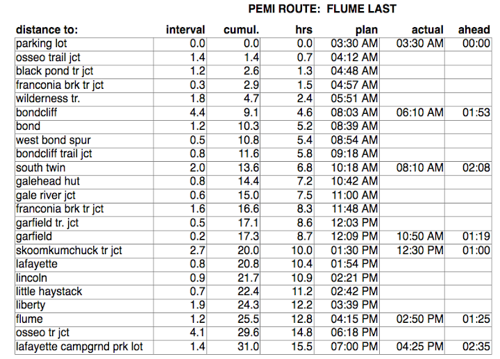
[Update:] See below for tMail's trip report. See graph at right for my ascent of Mt. Mansfield. I don't know my exact finishing time yet because I didn't stick around for them to post the results. When active.com posts the results I'll know for sure. In the meantime, I think it was around 46 minutes based on the data my watch logged.

mutha's Race Report (details that are hard to read without a shot of espresso):

  • I was able to maintain a pretty steady 10.4 min pace and, if you look at the graph, a very steady 54ft/min ascent rate. It's graphs like this that made me understand that given a choice of route, steep doesn't matter unless it gets technically challenging
  • I'll find out actual time, ranking and number of runners when active.com posts the results [Update: time was 47:11, 7 out of 29 in the 40-50 male category, 45 out of 270 overall]. Race results are posted HERE.
  • The race was pretty well attended for a first-time event. The mountain bikers had a 10 min head start - it looked like there were around 50-60 bikers. There seemed to be more runners, but all-in-all there were probably not more than 300 attendees. As suspected, there was a lot of high-end muscle as well as some out-for-fun folk (like the biker who had his little kid in a baby seat on the back of his bike and the lady who brought her two little girls (ages 8-10-ish) with her.
  • I passed about a dozen bikers, including the guy w/ the little kid and three unicyclists. I actually sprinted at the finish line to beat/tie a guy on a bike, which got approving laughs from the crowd since we were technically in different races.
  • Asthma was much better since I treated my gastric reflux. I held back a little, keeping my breaths at every third step, going to every other step on the steep turns and steepest stretches. The air was clear and dry (with a little dust from the dirt road) which aggravated the situation, but aside from some regular hacking, just basic labored, wheezy breathing.
  • Sue and Spanky came along and walked partway up the road to meet me (I ran down after a 45second look around the top). No photos - I didn't bring the camera.
  • Lunch was included in the registration price: pasta w/ two types of seasonings, excellent pizza, salad, etc. at the Matterhorn Restaurant down the road.

tMail's Trip Report:
Yesterday's outing covered roughly 14 miles that includes the walking around wondering where is 6 Husbands...where are we...what should we do? I swear to God Edmunds Col is a like a big hole that sucks you in and then doesn't tell you where your...but I did figure out exactly where Mutha and I were 2 years ago...

All and all great day out despite visibility:

  1. Vasque trail runners are the best never going to another brand again.
  2. EMS poles suck
  3. EMS sucks
  4. I lost feeling in both hands in August.
  5. Trail conditions dictate pace, distance that can be traveled as well as visibility.
  6. We ran into a nice family from Cooperstown, NY
  7. How come people ask how far to Madison Hut when the F'n sign 100 yards earlier said 3.9 miles???
  8. Westie is improving as a hiker and coming along nicely.
  9. I am looking forward to the Presi
  10. Vote Obama!!!

8.24.2008

Lonesome Lake Canoe Trip

The d.o.c. sent along this pic from the summit of the bad boy after the Dartmouth Outing Club hauled a canoe up and paddled around Lonesome Lake, then hauled the canoe to the summit and had it driven down in a truck.

If they'd done it in winter they could've done a canoe glissade.

8.23.2008

Sub 15:00 Straight Pemi Is Possible...

...in fact so is a sub 14h and a sub 13h. Specifically, 12:55, starting at 3:30am and Route Map
ending at 4:25pm. I'm trashed, so I'll post more details and photos tomorrow. Here are a few facts to chew on in the meantime:

  • I did it g-$$$-wise (counter-clockwise). I think it may be a little faster, but it seemed to be a lot harder. I hit Galehead Hut in 9 hours and then had Garfield, Lafayette, etc. and that goddamned Garfield Ridge Trail. By the time I hit Liberty I was dragging and I barely made it up Flume.
  • In order to come in under 13h I had to run (not trot) roughly Sunrise From Bondcliff
    the last 2 miles of the Osseo Trail and the Wilderness Trail back to the car - about four miles of running after 26 miles of hiking/running. I was trashed. I hit 12:55 about 15 feet from the car.
  • I consumed:
    - 5L of water
    - 1.5 flasks of Perpetuem/Gel paste
    - 8-12oz of my homemade granola
  • Some milestones:
    - parking lot to Bondcliff, 2.5hrs (just in time for sunrise)
    - parking lot to Galehead Hut, 9hrs
    - parking lot to Lafayette, 12hrs
  • Some pain:
    - I crashed to my right knee on a slippery rock and felt the kneecap jump two feet to the right. I almost cried.
    - The biting insects were really bad, especially on the summits (not really in the woods). Elevation vs. Time

    - Between Lafayette and Flume I saw more hikers that the entire total number of hikers I've ever seen in my entire life, excluding today.
[Update 8/24 - Pics are posted]:
-- Mutha's Pemi Loop Pics
-- Mr. & Mrs. PM were on the Bad Boy at the same time. The PM's Mt. Washington Pics
-- And finally, tMail's excursion w/ Westie to the 'Dacks

8.21.2008

Saturday Adventure

I'm thinking of doing a big speed-hike on Saturday, possibly a pemi (short 30 mile version) avoiding Galehead, North Twin and West Bond. I realize it's late notice, but I'd like to do it in under 15 hours, which means going g-$$$-wise (counter clockwise, trotting the wilderness trail first and coming down the Osseo from flume, possibly in the dark). I'd rather trot the Wilderness Trail in the dark so I'm planning on sleeping in my car and starting out by 3am.

Then of course I may wait until some other day this fall and do it with the group. I'm a little concerned about my schedule this fall so I may have to be aggressive and take weekend trips when I can.

If anyone is interested, it'll be fine weather. I'm taking NO extra clothing and I'm bringing the MSR water filter to keep my water load to 2L at a time. Just water and food and the filter.

8.20.2008

Mushroom Hunter 90 minute challenge

The 90min challenge: today i took the dogs for a walk and in 90 minutes tried to photograph as many different mushrooms as possible. clearly i have a lot of duplicates, but in most cases can't tell for sure.

[Link to photo gallery]

There is also at least one non-mushroom (the indian-pipes are chlorophyl-less flowers that grow in deep shade on decaying plant stuff).

Sue got me a gorilla-pod last weekend but I FORGOT IT at home and used a broken stick for stability. I didn't want to use the flash and in some cases the scene was so dark that I just couldn't get the camera still, even resting it on the ground.

8.19.2008

Race To The Top of Vermont

On Sunday, August 31st is the "Race To The Top Of Vermont" [Link] up the Toll Road of Mt. Mansfield. It's only about 2,550' vertical and 4.5 miles, but it's a fundraiser to finish the Catamount Trail (a winter-user backcountry trail stretching the length of Vermont). The road is all dirt (except for 0.3mi at the beginning.

I've signed up, partly as a supporter of the trail but also to get in a fun race. Anyone planning on being in Vermont that Sunday, consider signing up.

[Update: See this post above for details of race, including link to race results]

8.16.2008

Pierce & Eisenhower Trip Report

It was great day out! Rain, hail, lightning, thunder and good company: tMail, Westie, Mutha, Spanky and new to the group, Helen representing the DOC (Dartmouth Outing Club). Mutha's & the DOC's pics are here and they pretty much say it all... except the hail and lightning.

The hail came suddenly and frequently and abundantly enough to accumulate in patches. At Eisenhower, The DOC, Spanky and I headed back to the car while Westie and tMail continued on. About 20 minutes later the dynamic duo came up from behind. Things were getting a little bit more dramatic for all parties as the clouds, wind and rain picked up and we polished off (or nearly polished off) the DOC's chocolate chip cookies.

But it really was an extraordinarily beautiful day.

[Update 8/17] I edited the original post and re-uploaded my pics at a higher resolution to do justice to the cloud color variations and uploaded some pics from The DOC. All pics are here.

And tMail has uploaded his pics. He even captured Cog Doom!

[Update 8/18] tMail has added captions to key photos, and added some additional 'special' photos for the mega-Doom crowd - sure signs of the apocalypse.

tMail's Gear Test and Trip Reports

Well it was a nice day to get back into the grove of mountain life and get the legs going up again. It was nice to go for a hike at a relaxed pace and just enjoy being out...I also got to test some gear...

Results of Gear Test:
  • Darn Tough are Darn Tough...if you don't notice them on the feet then you know they are good
  • Brooks Trail runners great shoe for flat sandy trails ok on the rocky stuff...super lite and drain extremely well...
  • Marmot precip unbeatable...
Trip Report:
  1. Hail is great
  2. Lighting is even better
  3. The Weather is fascinating when you see 3 separate storms forming on you now you are in trouble
  4. Cotton t-shirts and trash bags is a great look especially when you are walking directly into a storm.
  5. I can't seem to find a dry trail to hike on o well...
  6. Just walking on a trail that has water running down it is a welcome sight vs running through mud up to your crotch and having a gravel bank in your shoes
  7. Presi Traverse is going to be exciting
  8. Great to meet DOC
  9. Great to get the Yellow Comet out.
  10. I am ready for the 4 summit attempt in the Dacks on 8/22/2008

8.12.2008

Saturday 8/16

tMail is motivating... we're on the move... ideas are coming ... stay tuned.

my maps have been gathering dust, but from memory, here are some of mutha's suggestions (old ideas that keep floating around). these are all pretty big hikes:

  • from rte 112 outside of north woodstock, in Kinsman Notch, take Kinsman Ridge trail north all the way over the Kinsmans, Cannon and end at Cannon Mtn parking lot. requires spotting car. alternatively, take kinsman ridge trail north to South kinsman, turn around and head back to car. trail looks very different in either direction - doesn't feel like round-trip on same route.
  • mt. carrigain (signal ridge) to nancy pond trail via stillwater junction. requires spotting a car. trail around nancy pond/norcross pond may be submerged.
  • shoal pond/thoreau falls trail loop (from 302)
  • signal ridge to wilderness to thoreau falls trail, ethan pond to rte 302. or the reverse of that. requires spotting a car.
  • from the end of sawyer river road, hancock notch trail to cedar brook trail to wilderness to desolation to signal ridge and back to sawyer road. haven't counted, probably almost 25 miles.
  • Hale brook to Hale, over Hale to Lend-a-hand, twinway, zeacliff, ethan pond, back to car.
  • Rocky Branch (from Jericho Rd off 302 right before rte 16) to isolation trail to Davis path, davis path back to stairs mtn and stairs col trail, return to car.
  • more to come ...
[Update 8/14/08] We're going Low Gear. We're turning our first post-Jay outing into more of a take-a-deep-breath and enjoy the sights kind of hike. tMail and I will probably be joined by at least three others including Spanky The Wonder Dog. The pace will be casual and the route may end up being different for different folks. The basic route will be:
  • From Crawford Notch at the Mt. Clinton parking area (across the road from the AMC Lodge), take the Crawford Path north over Pierce & Eisenhower, return the same route.
  • Variation 1: For those interested, continuing on and hitting Nixon and Monroe with an option for Lake of the Clouds.
  • Variation 2: Return via the Dry River Wilderness and the Mt. Eisenhower cutoff to Mizpah Hut.
I'm going to be test-driving a brand-new pair of boots. Oh yeh, and for the record, the big-toenails I destroyed on each foot have been removed. I used a pair of needle-nosed pliers to pull them out since my tweezers couldn't grip hard enough. It didn't hurt that much, but my toes are a bit unprotected. I did a 40mile bike ride the same day and they got kind of sore, but not infected. I may post a photo. (Click toenail to enlarge.)

[Update 8/14, 9:30pm] Could have some thunderstorms on Saturday. Be prepared to seek shelter off the bare ridge.

8.06.2008

The Upcoming Calendar Of Events

The rain persists. Noah had the right idea.

It's been raining so much that the water in my back yard is flowing uphill. The most invasive weeds in the lawn right now are cattails and water lillies. I don't have to mow my lawn, I have to kayak it. My dogs go out to chase frogs when they have to pee. There are no mosquitos - they've all been washed away.

Here's all we've got firmly printed on the calendar:

August 23rd: Hike in the Whites (route to be determined)
September 13th: Presi Traverse
September 20th: Pemi Loop
September 27th: 3rd Annual SHAG race

8.01.2008

Next Up: Nuthin'

tMail called today to suggest a romp in the Whites tomorrow (Saturday, 8/2). I'm a little reluctant because of the heavy rain in the forecast and the rain for the last two weeks. I've got standing water in my back yard that's been there so long I now have frogs living in it. Crap.

I don't want to spend the day with wet feet, so I'm opting out.

Oh yeh, and Steve Wolf posted some great pics of the Jay race here. In particular, the one posted here from his site of the beaver pond. I have yet to see a pic of somebody going under.