2.29.2008

Tyday At Franconia Notch

tMail On Lincoln

It was -20°F in Danville when I set out this morning, but as much as it was cold, it was that much fun. Another glorious blue-sky day with low wind. In a weird lull that started around midnight this morning and is now coming to an end, the winds just died. At most we had what could be called a light breeze that was probably more due to upslope convection.

And the visibility? Holy crap. We could easily see from Jay Peak south to Killington along the entire spine of the Greens. Trip reports and links to picture galleries will be posted as they are generated, so check back soon.

Also, tMail and I met a guy on the OBP who referred to "Lincoln's Throat". tMail hunted around and found this. Even though the original plan for our hike on Tyday was to bushwack the west ridge of Lincoln, it seems clear that the gullies/slides in the big ravine are likewise appealing. We think there are two interesting hikes: climbing up the low-angle ice in the ravine and climbing the ridge to Lincoln. This spring, for sure.

  • Mutha's Pics are now posted on Picasa [Link]
  • tMail's Pics are now posted on Picasa [Link]
  • The MPM's Pics are now posted on Picasa [Link]
  • tMail's Video is now posted on YouTube [Link]

2.27.2008

Fridays at Tuckerman's: You, Me & The Man Who Cried 'Beaver'

All signs are pointing to a day at Tuckerman's on Friday. While the weather will likely be somewhat overcast and possibly snowy, the temperatures are getting milder these days. This was the time of year that tMail and MD and I wandered around in the frozen fog on the Bad Boy and took the now-famous video (YouTube).

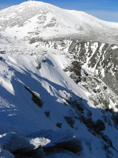
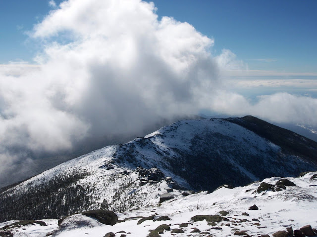
The pic at right at the top was taken last Sunday and was posted at tuckerman.org and is of the top of Dodge's Drop looking toward the summit cone.

The lower pic was taken by me on January 13th and a comparison shows how much the summit and ravine has filled in.

We'll post details of the trek on Friday as The PM and Tyler make their intentions known.

[Update 2/28 11am] Via The Puppet Master: Meet at Pinkham Notch Lodge at 8:30am on Friday, 3/1. Prepare for the Lion's Head route.

[Update 2/28 2pm] Via The Puppet Master (See Comments): Plan B. Do NOT meet at Pinkham. Repeat: Plan B! ... Plan B continued....Meet in the east Lafayette Place parking lot at 8:30. That means, If I understand my points-of-the-north-south-finder, the side of Franconia Notch at the bottom of the west slope of Franconia Ridge, most readily accessed from the north-bound side of rte 93 via the turn just past "The Basin" and just past where 93 merges from two lanes to one. This would be, I should clarify, the opposite side of the highway from where the ranger station is, and also the opposite side from where the campground, lake and Cannon Mtn are.

If I may further elucidate, if you were heading north on 93 through Franconia Notch, this would be a right turn directly into the parking lot where the Old Bridal Path trailhead is, as well as access to the Falling Water trail and the payphone that is now almost buried in snow.

And in case there is still ambiguity, go up to North Kinsman mountain. Face the noon-day sun. Point left at where you should have gone, and that's where we'll be.

2.25.2008

Dead Man's Ridge: The Fool Killer (Franconia Ridge)

As promised, I headed up to Dead Man's Ridge yesterday in the bright sun and blue sky. It was surprisingly cold out but the winds were light and the ridge was manageable with base layers and my light yellow windbreaker. I had to put my face-mask on frequently in the windy sections but no goggles were needed. I don't know what the conditions were - probably about 15°F or higher with 20mph winds in the windy spots. There wasn't a single person on Falling Waters or on the Ridge while I was up there. The drifts from the previous night were all fresh. The first person I met was on the Lafayette summit, doing the Loop in reverse. Of course there were many people on the OBP, including the hockey players (heading down).

In a major reversal of my normal cordiality, I gave one-word answers to all questions from the n00bs:

"How was it up there?" "Fine."... "Is it windy at the Summit?" "No." ... "Can you bareboot the ridge?" "Yes."... "This is steep. Is it far to the ridge?" "No."

As long as you look at things from my point of view, those answers were correct - although when they encountered the cold, gusty winds, the thick ice and the steep ascents they may have thought otherwise.

The hike was crampons-only until the Hut, then barebooting down to the parking lot. As the PM saw yesterday, trail conditions were well-packed. The worst part was that all the thawed ice/snow on the trails was now frozen solid and covered with a light layer of snow. This meant that all past post-holes were like cement pits. To slow my speed on the steeps it was easier to head into the soft shoulder, which was firm enough so that I never really dropped deeper than 6-12 inches even though the snow was up to the trail blazes on the trees. The descent was pretty fast and a no-brainer to bare-boot/butt-slide/boot-ski.

The air was very clear, in spite of a low-level haze. Pics are posted here. Regrettably, without any clouds at all, the scenery was kind of boring - visibilty over a 100 miles and just bright snow, well-packed trails and no annoying conversations until the descent - and those were brief. No wonder people die up there.

Sunrise Over The Whites

This morning I waited with Sue for the Rte 2 commuter van. It was clear last night as this last cold front firmed up any last moisture in the snowpack in preparation for Tuesday's storm. We watched the colors develop in the sky as the last stars hid from the dawn.

After she left I took a few shots around Danville and caught sunrise over Mt. Washington and first light on Lafayette. The shots were taken from Danville. Click here to view Picasa album.

2.24.2008

The PM Mangles Dead Man's Ridge

In a revenge killing worthy of World News Weekly headlines, the PM has completely destroyed Franconia "Dead Man's" Ridge. Where once a high ridgeline with dramatic peaks punctuated the skyline of Franconia Notch, now a rubble pile fills an inconsequential swamp. The technique was to apply pressure with his size 13's in repeated kicks and stomps, then to "bareboot the poor bastard". The PM was was asked if there was any emotional fallout from this wholesale slaughter. He replied quietly after an introspective pause "No". Pic at right shows the ridge being destroyed.

I have to pick up some copper fittings at Home Depot in Littleton today. I think I'll head down to Franconia Flats on my way and take some pics.

2.22.2008

Undead Reckoning

This isn't about re-animating zombies - it's about the surprising consequences of two route-finding experiments that were totally astonishing. Last Sunday, before the big rain episode, and today, as the snow started, Spanky and I went into the woods and marshes for some adventure. The idea was to snowshoe off-trail, away from our own prior tracks and explore the local terrain on days when there was completely flat light. The question to answer was: given the tangle of swamps, dense red-pine forests, rolling terrain and lack of prominent geological features, sun or compass, how hard is it maintain a mental map.

The area we were exploring is about four square miles behind my house. The largest change in elevation over the course of an hour-long trek is less than 100ft. The largest elevation change in a single ascent/descent would be about 10-15ft down to a brook - at most. The character of the land is, of course, snow-covered and dense woods punctuated by open and woodland marshes, beaver ponds and streams. All the farmland and pasture is on the periphery as this regions is too rough and boggy to farm. I'm sure at one time it was logged, and at times it seems as if we're coming across old road-grades - but in general there aren't any prominent features to give visual clues as to where in the heck you are. The fir and pine grown so close in patches that it seems almost impenetrable. It's also inevitable that if we hit a stream bank, that we'd follow along until finding a crossing.

Our trek Sunday was to just go out and wander around until we came out somewhere we recognized. This isn't dangerous because in general, the nearest road is within a 45minute slog as long as you're not going in a circle.

Our mission today was to head south (without a compass) for a while, then west, then work our way in a 'clockwise' loop back home.

In both cases we wanted to explore areas we hadn't been before.

Here's what happened in both cases: we came out at places we recognized and in BOTH cases we had circled counter-clockwise even though I thought we were working our way clockwise. Now I have a pretty-good (I think better than average) sense of direction - but this was a total surprise. With no visual cues other than just keeping a mental tally of turns I screwed up so bad I actually looped around in the OPPOSITE direction. It was so startling that during the week we retraced Sunday's trek in the opposite direction, following our trail in the bright sun and blue sky. It was completely stupid. The trail clearly looped in an obvious way - but when the sun is out this stuff is almost mindless. In retracing my steps I had no idea how I COULDN'T have known where I was heading, but I knew I had been totally confused - thinking I was heading south when I was heading north at times. That's bad.

But then it happened again today.

Now admittedly we designed the trek to be difficult. These woods and swamps are very challenging to navigate and even the easiest routes twist and turn horribly. If I had a compass, an attempt to walk due east, for example, would last about a minute and then require looping around to bypass something. But man, coming out on the OPPOSITE side of my starting point from where I thought I'd emerge was really disorienting. At least on a mountain we have 'down' and 'up' to help guide. These woods are like a freaking black hole.

In the map on the right, the blue route is where i thought i was going (roughly). the red and green routes are from Sunday and today, and aren't at all exact, but rough guesses at where I was. The big 'dots' are at the end of the treks before heading home on recognizeable routes.

2.20.2008

Next Trip

My nieces are coming to visit today for a few days, leaving Saturday (Ruby is driving up with her sister Hattie and Ruby's friend Caroline - it's a ROAD TRIP!). We're going to do some skiing, snowshoeing and sitting around so I'm not doing a big hike until Sunday.

I'm going to be watching the re-freezing of the snowpack and if things shape up there could be some outstanding cramponing terrain (axe mandatory). tMail, if you think you'll be going out on Sunday we can always tackle one from your list. If I'm going alone or with the Vermont contingent, I'll probably take another crack at Bamforth.

Bad, Bad, Bamforth.

I'm also really interested in checking out the avalanches on Mt. Washington. Check out Chauvin Guide's Jay Philbrick's recent post and photos.

2.18.2008

Data Courtesy of IBM's Many Eyes Visualization

The same plot from the previous post, uploaded to IBM's Many Eyes web service (think Flickr for info-visualizations). The plot can be viewed there as well as embedded in this blog.

[Update 2/19 1030pm] Added additional dimension. Little dots are single summit hikes. Medium dots are Two-Summit hikes (Hancocks, Jefferson/Adams, Pierce/Eisenhower, etc.). Huge dots are treks, like the Carter traverse or the Dry River Wilderness hike.

The darker the dot the more times I've done that same hike.

2.17.2008

Tallying 2006 To Today

If I add up miles and feet of elevation for all hikes, excluding regular runs and exercise, but including the Jay XC marathon and the two MRG snowshoe races, I get the following:

Total Miles: 771
Feet of Elevation: 260k

I started the clock with the Osceolas hike w/ Treadmill back in early Feb 2006 (followed by the 2006 Bad Boy). So this plot excludes all the presi-traverses I've done and all earlier hiking. I didn't feel like going back to 2005 when my record-keeping was spottier.

This also excludes about 600 miles and thousands of vertical feet of biking, kayaking, downhill/backcountry/xc skiing, marathons and other races and is basically just backpack hiking. One day I may go back further, but it's not likely at this point.

Check out these two graphs. The XY plot is interesting but the three colored lines are just for fun and I don't think the three lines mean anything. The data seem to group naturally into three 'types' - but I think that has more to do with the hikes I like and the tendency to see patterns where there are none.

2.16.2008

Bamforth Has Struck Again

The Bamforth Ridge Trail has struck again, claiming two victims today: Mr. Mutha from Danville, and Mr. MadDog from Richmond (or is it Jeffsonville? or Underhill? or Allah knows where?).


Did we have to turn back shy of the summit of Camel's Hump? Not a chance. Rather than intimidate us into turning back after demanding a sacrifice of blood, the Bamforth trail used another tactic today: evasive maneuvers. It went away. We were about 10 minutes into the hike and that was the last we saw of it. Worse still, we ended up on a small mini-summit one ridge over. When we finally got a look around after a bushwack reminiscent of Hell Brook, we saw the view shown in the pic at right. We were over two hours into an aggressive bushwack and we wanted to be on the ridge in the distance. Between us and that ridge was classic, contorted, snowy, rugged Green Mountain topography. We dropped into the little valley and had lunch on a big beaver pond and then turned around and followed our trail back to the car.

Of course the conversation was great, the weather was bitter cold (low wind, but biting, bitter, sapping cold - I think it was below 5°F) but the sun was bright and the company excellent. There were song birds out, really large, fat chickadees and woodpeckers. To give an idea of the cold, note that I normally ascend in light windstopper or nylon/lycra gloves/liners like we all use. On this day I wore my insulated gloves - on the ascent! And that was while bushwacking in steep, deep snow.

And best of all, at the beaver pond, Mad Dog pulled out a large thermos filled with hot tea, sweetened and with milk. Man, in that bitter cold sunshine it was the greatest thing. I had started to get deep body-trembles from lowering core-temp and that tea kicked ass. Even though we stood in the full sun in dark clothes, it was a toss-up between whether the cold or sun would win. Hot, sweet tea. I'm hooked.

I'd also like to point out that while the air was cold, the snow was colder, and we were breaking trail. We both noticed our feet were getting cold, in spite of the insulated boots and the hard work.

We'll try Bamforth again another day.

For anyone with a topo map out, the height-of-land where the picture was taken is a feature with an elevation of about 2,360, located at a bearing of 10° west of true north of the Camel's Hump summit. I'm going to find it on Google Earth and get an annotated pic up. This place was out of control. Pics coming later tonight.

[Update 2/16 18:31] Found our bushwack on Google Earth. Click on lower pic on the right to zoom. Pic of MadDog (above right) was taken on the little mini-summit w/ exposed ledges.

What can't be seen in this picture is how steep this hike was and how rugged and beautiful the terrain is. It reminds me how extraordinary the Green Mountains are. I can recall several conversations with people from other states who have hiked in the Greens and commented on how unprepared they were for the beauty and challenging hiking.

tMail and g-$$$: we'll drag you up here soon.

We got back to the car pretty early (I think it was around 2:30 after a 7:45am start) so MD got to his 5pm party and with the bright sun and blue sky, I got home in time to take a nice 50min cruise on XC skis with Spanky. I had my fast skis out on some groomed trails and got a little overzealous on some tight turns and crashed into some brush/tree/snow stuff. My hip hurts. Ow.

I don't know about down south, but this cold snap is about to end with temps in the 40's by Monday and snow, sleet, freezing rain and rain in the forecast for Sunday night and Monday.

Yay winter.

[Update 2/17] Pics are posted at Picasa [Link].